Pacasmayo
| Pacasmayo | |
|---|---|
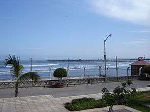 Pacasmayo pier seen from shore | |
 Pacasmayo | |
| Coordinates: 7°24′1″S 79°34′12″W / 7.40028°S 79.57000°WCoordinates: 7°24′1″S 79°34′12″W / 7.40028°S 79.57000°W | |
| Country |
|
| Region | La Libertad Region |
| Province | Pacasmayo |
| Government | |
| • Mayor | Oscar Honorio Horna |
| Population | |
| • Estimate (2015)[1] | 27,514 |
| • Demonym | Pacasmayino(a) |
| Time zone | UTC-5 (PET) |
| Website | Municipality |
Pacasmayo is a city in Northern Peru, in the Pacasmayo province, La Libertad Region. It is located 108 km north of Trujillo city.
Transportation
- Panamerican Highway, connects with north and south the country.
- Pacasmayo Port, connects to the world by the sea.
Tourism
- Pacasmayo beach visited by surfers commonly.
 Pacasmayo
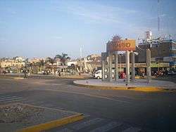
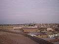 Pacasmayo overlook
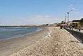 Pacasmayo Beach
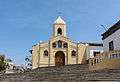 Notre-Dame of Guadalupe Church
History[2][edit | edit source]
Pacasmayo has been inhabited for over 10,000 years by groups of people collecting their food from the sea. Since before anyone can remember, the beaches of "El Lorito", "El Techito" and "La Peña Larga" have provided food sources to populate Pacasmayo. With the available food from the sea and the forests in the arid mountains (close to the river Jequetepeque) which provides carob trees (or locust beans), wool, and diverse species of animals; Pacasmayo (or Pacasca Mayo in Quechuan) was chosen as a settling place for small tribal groups.
By order of Virrey Teodoro de Croix in the year 1775, the Spanish conquistadors founded Pacasmayo. Since that time it became an important landing for the Spanish crown. The year of 1871 began the construction of the Pacasmayo dock or "muelle de Pacasmayo" and the train Pacasmayo-Chilete, which turned into an important Peruvian coastal port.[3][4] This work of engineering began the golden age of Pacasmayo which lasted until 1967, the year when the railway stopped running. Since that time, the commercial activity has decreased to the point where now the dock, just as the railway station, are historic monuments. They are evidence of a glorious past that brought with it an economic boom to the city.
The company “Cementos Pacasmayo SA” [5](Pacasmayo Concrete Inc.), which began in 1959, quickly became the new axis upon which the economy of the city developed. Its presence promoted the development of many economic services such as businesses that transport heavy loads, banks, and commercial stores. All depended on this central industry.
Since the end of the 20th century, the breakwater area, El Faro (The Lighthouse), dominated as the “largest, most navigable wave in the world” and has gained popularity among water-sport fans. At that beach, one can practice surfing, windsurfing, kitesurfing, and paddle-boarding which promotes the growth of foreign visitors who arrive from diverse parts of the world to enjoy these waves.
Further Reading[edit | edit source]
"Posibilidades de aprovechamiento de aguas subterráneas para las tierras de Santa María (Pampas de Pitura y Guereque)." Ministerio de Fomento y Obras Públicas. Dirección de Irrigación. Autoridad Nacional del Agua, 01 Apr. 1969. Web. 21 Feb. 2017.
References
- ↑ Perú: Población estimada al 30 de junio y tasa de crecimiento de las ciudades capitales, por departamento, 2011 y 2015. Perú: Estimaciones y proyecciones de población total por sexo de las principales ciudades, 2012-2015 (Report). Instituto Nacional de Estadística e Informática. March 2012. Retrieved 2015-06-03.
- ↑ "Pacasmayo". Wikipedia, la enciclopedia libre (in Spanish). 2017-02-02.
- ↑ "World Scholar: Latin America & the Caribbean - Document". worldscholar.tu.galegroup.com. Retrieved 2017-02-22.
- ↑ "World Scholar: Latin America & the Caribbean - Document". worldscholar.tu.galegroup.com. Retrieved 2017-02-22.
- ↑ "Cementos Pacasmayo". Retrieved 2017-02-22.
See also