Ozama River
| Ozama | |
| River | |
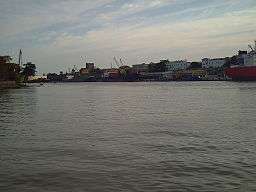 Ozama River in Santo Domingo | |
| Country | Dominican Republic |
|---|---|
| Tributaries | |
| - left | Savita, Yabacao |
| - right | La Isabela River |
| Source | |
| - location | Loma Siete Cabezas, Sierra de Yamasá, Dominican Republic |
| Mouth | |
| - location | Caribbean Sea, Dominican Republic |
| - elevation | 0 m (0 ft) |
| Length | 148 km (92 mi) |
| Basin | 2,685 km2 (1,037 sq mi) |
The Ozama River (Spanish: Rio Ozama) in the Dominican Republic rises in the Loma Siete Cabezas in the Sierra de Yamasá, close to Villa Altagracia.
In 1498, Bartolome Colon had a fort built on the Ozama. The estuary at that time, "teemed with fish and where the Indians raised cassava and yams," according to Floyd.[1]
The river flows 148 kilometers (92 mi) before emptying into the Caribbean Sea. At the end of the journey it bisects the capital, Santo Domingo, into eastern and western halves. The three main tributaries of the Ozama are the Isabela River, the Sabita River and the Yabacao River.
The Ozama's basin is the fourth largest in the Dominican Republic. The river has several tributaries, with a combined area of 2,706 square kilometers (1,045 sq mi). The river basin has an annual precipitation of 2,250 mm (89 in) per year.[2]
The River Ozama is heavily polluted. It is constantly affected by the slums on its shores. It is one of the main causes of pollution on the coastline of Santo Domingo.
References
- ↑ Floyd, Troy (1973). The Columbus Dynasty in the Caribbean, 1492-1526. Albuquerque: University of New Mexico Press. p. 34.
- ↑ "Environment Master Plan aims to recover Ozama River basin". Dominican Today. Retrieved 19 February 2014.
[1]Coordinates: 18°28′00″N 69°53′00″W / 18.4667°N 69.8833°W
- ↑ 2006-2016, Merit Designs Consulting Group,. "Recovering Santo Domingo's rivers". DominicanToday (in Spanish). Retrieved 2017-10-02.