Owens Cross Roads, Alabama
| Owens Cross Roads, Alabama | |
|---|---|
| Town | |
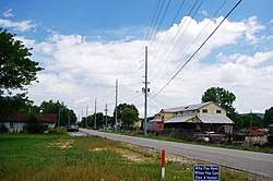 Old Highway 431 in Owens Cross Roads | |
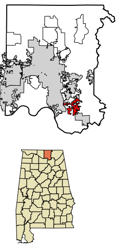 Location of Owens Cross Roads in Madison County, Alabama. | |
| Coordinates: 34°35′10″N 86°27′31″W / 34.58611°N 86.45861°W | |
| Country | United States |
| State | Alabama |
| County | Madison |
| Area[1] | |
| • Total | 8.40 sq mi (21.75 km2) |
| • Land | 8.28 sq mi (21.44 km2) |
| • Water | 0.12 sq mi (0.31 km2) |
| Elevation | 581 ft (177 m) |
| Population (2010) | |
| • Total | 1,521 |
| • Estimate (2017)[2] | 1,939 |
| • Density | 234.26/sq mi (90.45/km2) |
| Time zone | UTC-6 (Central (CST)) |
| • Summer (DST) | UTC-5 (CDT) |
| ZIP code | 35763 |
| Area code(s) | 256 |
| FIPS code | 01-57504 |
| GNIS feature ID | 0155184 |
Owens Cross Roads is a town in Madison County, Alabama, United States, and is included in the Huntsville-Decatur Combined Statistical Area. It was incorporated in 1967.[3] As of the 2010 Census, the population of the town was 1,521.[4]
History
Owens Cross Roads first appeared on maps in 1850, and was named for a family of early settlers. A post office was established in 1861. The town relied heavily on cotton cultivation throughout much of its early history, with some crop diversification coming in the 1920s and 1930s.[3]
Geography
Owens Cross Roads is located at 34°35′10″N 86°27′31″W / 34.58611°N 86.45861°W (34.586071, -86.458561).[5] The town is situated in a broad valley carved by the Flint River. Rugged hills and mountains surround the town, including Green Mountain to the west, and Keel Mountain to the east. Huntsville lies across Green Mountain to the northwest, New Hope lies just to the southeast, and Paint Rock lies across Keel Mountain to the northeast. U.S. Route 431 passes through Owens Cross Roads, connecting the town with Huntsville and Guntersville.
According to the U.S. Census Bureau, the town has a total area of 8.4 square miles (21.8 km2), of which 8.3 square miles (21.5 km2) is land and 0.12 square miles (0.3 km2), or 1.42%, is water.[4]
Demographics
| Historical population | |||
|---|---|---|---|
| Census | Pop. | %± | |
| 1970 | 767 | — | |
| 1980 | 804 | 4.8% | |
| 1990 | 695 | −13.6% | |
| 2000 | 1,124 | 61.7% | |
| 2010 | 1,521 | 35.3% | |
| Est. 2017 | 1,939 | [2] | 27.5% |
| U.S. Decennial Census[6] 2013 Estimate[7] | |||
As of the census[8] of 2000, there were 1,124 people, 443 households, and 329 families residing in the town. The population density was 145.8 people per square mile (56.3/km²). There were 482 housing units at an average density of 62.5 per square mile (24.1/km²). The racial makeup of the town was 95.64% White, 0.71% Black or African American, 0.71% Native American, 0.27% Asian, 0.36% from other races, and 2.31% from two or more races. 0.62% of the population were Hispanic or Latino of any race.
There were 443 households out of which 29.8% had children under the age of 18 living with them, 60.0% were married couples living together, 9.9% had a female householder with no husband present, and 25.7% were non-families. 21.9% of all households were made up of individuals and 8.6% had someone living alone who was 65 years of age or older. The average household size was 2.47 and the average family size was 2.88.
In the town, the population was spread out with 23.3% under the age of 18, 8.4% from 18 to 24, 29.6% from 25 to 44, 24.7% from 45 to 64, and 14.0% who were 65 years of age or older. The median age was 38 years. For every 100 females, there were 95.8 males. For every 100 females age 18 and over, there were 95.0 males.
The median income for a household in the town was $34,856, and the median income for a family was $45,167. Males had a median income of $30,781 versus $22,917 for females. The per capita income for the town was $17,534. About 4.6% of families and 7.1% of the population were below the poverty line, including 8.9% of those under age 18 and 11.8% of those age 65 or over.
2010 census
As of the census[9] of 2010, there were 1,521 people, 593 households, and 409 families residing in the town. The population density was 183 people per square mile (70.7/km²). There were 650 housing units at an average density of 78.3 per square mile (30.2/km²). The racial makeup of the town was 91.5% White, 3.6% Black or African American, 1.0% Native American, 0.3% Asian, 0.6% from other races, and 3.0% from two or more races. 2.2% of the population were Hispanic or Latino of any race.
There were 593 households out of which 30.4% had children under the age of 18 living with them, 53.3% were married couples living together, 10.5% had a female householder with no husband present, and 31.0% were non-families. 27.0% of all households were made up of individuals and 8.7% had someone living alone who was 65 years of age or older. The average household size was 2.41 and the average family size was 2.91.
In the town, the population was spread out with 23.1% under the age of 18, 7.8% from 18 to 24, 28.3% from 25 to 44, 23.9% from 45 to 64, and 16.9% who were 65 years of age or older. The median age was 38.1 years. For every 100 females, there were 97.0 males. For every 100 females age 18 and over, there were 107.0 males.
The median income for a household in the town was $40,625, and the median income for a family was $43,750. Males had a median income of $43,889 versus $33,393 for females. The per capita income for the town was $21,542. About 23.6% of families and 31.2% of the population were below the poverty line, including 60.9% of those under age 18 and 6.1% of those age 65 or over.
Notable people
- Edward Troye, painter[3]
References
- ↑ "2017 U.S. Gazetteer Files". United States Census Bureau. Retrieved Jul 7, 2018.
- 1 2 "Population and Housing Unit Estimates". Retrieved March 24, 2018.
- 1 2 3 Christopher Maloney, "Owens Cross Roads," Encyclopedia of Alabama, 1 July 2014.
- 1 2 "Geographic Identifiers: 2010 Demographic Profile Data (G001): Owens Cross Roads town, Alabama". U.S. Census Bureau, American Factfinder. Retrieved February 1, 2013.
- ↑ "US Gazetteer files: 2010, 2000, and 1990". United States Census Bureau. 2011-02-12. Retrieved 2011-04-23.
- ↑ "U.S. Decennial Census". Census.gov. Retrieved June 6, 2013.
- ↑ "Annual Estimates of the Resident Population: April 1, 2010 to July 1, 2013". Retrieved June 3, 2014.
- ↑ "American FactFinder". United States Census Bureau. Retrieved 2008-01-31.
- ↑ "American FactFinder". United States Census Bureau. Retrieved 2015-08-01.
External links

Coordinates: 34°35′10″N 86°27′31″W / 34.586071°N 86.458561°W
Municipalities and communities of Madison County, Alabama, United States | ||
|---|---|---|
| Cities | 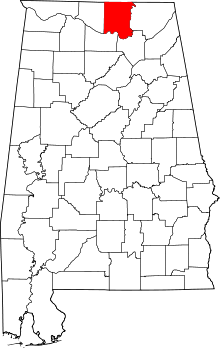 | |
| Towns | ||
| CDPs | ||
| Unincorporated communities | ||
| Footnotes | ‡This populated place also has portions in an adjacent county or counties | |