Oulton Broad South railway station
| Oulton Broad South | |
|---|---|
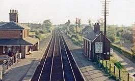 Oulton Broad South in 1985 | |
| Location | |
| Place | Oulton Broad |
| Local authority | Waveney |
| Grid reference | TM518922 |
| Operations | |
| Station code | OUS |
| Managed by | Abellio Greater Anglia |
| Number of platforms | 1 |
| DfT category | F2 |
|
Live arrivals/departures, station information and onward connections from National Rail Enquiries | |
| Annual rail passenger usage* | |
| 2012/13 |
|
| 2013/14 |
|
| 2014/15 |
|
| 2015/16 |
|
| 2016/17 |
|
| History | |
| 1 June 1859[1] | Opened as Carlton Colville |
| 26 September 1927 | Renamed Oulton Broad South |
| National Rail – UK railway stations | |
| * Annual estimated passenger usage based on sales of tickets in stated financial year(s) which end or originate at Oulton Broad South from Office of Rail and Road statistics. Methodology may vary year on year. | |
|
| |
Oulton Broad South railway station is on the East Suffolk Line in the east of England, and is one of two stations serving Oulton Broad, Suffolk. The other is Oulton Broad North on the Wherry Lines. Oulton Broad South is the next station along from Lowestoft on the line to Ipswich, and from Lowestoft the line crosses Mutford Bridge with a view of Lake Lothing to the east and Oulton Broad lake to the west. The station is 115 miles 42 chains (185.9 km) measured from London Liverpool Street via Ipswich.
It is managed by Abellio Greater Anglia, which also operates all trains that call.
History
Originally the station was named Carlton Colville, but it was renamed in 1927 to Oulton Broad South. The station was part of the 1984 modernisation of the East Suffolk Line. By 1986, the line was equipped with automated level crossings and radio signalling. However, to ensure the line's survival, two sections were also singled.
At the eastern end of the platforms the lines passed under a main road from Beccles to Oulton Broad, and just east of this point the line to Lowestoft had a junction to the Kirlkey branch, a single-track branch line designed to service a number of sites on the southern side of Lake Lothing. This line also served the Kirkley goods depot adjacent to Beaconsfield Road and the Fen Park. The branch was closed in stages during the 1960s and 1970s, as some of the larger businesses it served also closed down. The line from Durban Road to the goods yards was closed in 1967, although much of the track remained in place until the final closure of the line on 31 December 1972. The final section of the goods yard from the bridge in Mill Road is now a car-park, and a school playing field occupies the site of the other four-siding yard near the park. The line adjacent to the junction with the East Suffolk Line is now a residential caravan site, although the remains of the track bed continue along Victoria Road heading east. Numerous properties have been built on sections of this line.
The signal box at the junction was demolished and no trace remains. Signalling functions were transferred to the box at Oulton Broad North.
Services
As of December 2016 the typical Monday-Saturday off-peak service at Oulton Broad South is as follows:
| Operator | Route | Rolling stock | Typical frequency |
|---|---|---|---|
| Abellio Greater Anglia | Lowestoft - Oulton Broad South - Beccles - Brampton (on request) - Halesworth - Darsham - Saxmundham - Wickham Market - Melton - Woodbridge - Ipswich | Class 153, Class 156, Class 170 | 1x per hour in each direction |
On Sundays frequency reduces to one train every two hours in each direction. Trains extending to and from London Liverpool Street were withdrawn in 2010.
One weekday early-morning train is extended through to Harwich International and there is a return from there in the evening.[2]
References
External links
- Train times and station information for Oulton Broad South railway station from National Rail
| Preceding station | Following station | |||
|---|---|---|---|---|
| Abellio Greater Anglia | ||||