Oudong
| Oudong ឧដុង្គ | |
|---|---|
| Town | |
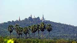 Phnom Oudong | |
| Nickname(s): City of Past Kings | |
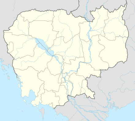 Oudong Location of Oudong, Cambodia | |
| Coordinates: 11°49′26″N 104°44′33″E / 11.82389°N 104.74250°E | |
| Country |
|
| Province | Kampong Speu Province |
| District | Oudong |
| Time zone | UTC+7 (Cambodia) |
Oudong (Khmer: ឧដុង្គ) (also romanized as Udong or Odong) is a town in Cambodia, situated in the north-western part of Kampong Speu Province. Located at the foothill of the mountain Phnom Udong, about 40 km northwest of the modern capital Phnom Penh, Oudong was royal residence and Cambodia's capital for more than 250 years until 1866. A monumental royal necropolis of sovereigns of several centuries is scattered on top the prominent bisected mountain, which runs from the southeast to the northeast.[1][2]
Etymology

The city's name is derived from the Sanskrit word "uttuṅga" (Sanskrit: उत्तुङ्ग), meaning tall, which probably refers to the mountain. As it had gained religious merit and significance it might have undergone extension towards: "great" or "supreme".[3]
History
Oudong was founded by King Srei Soryapor in 1601, after the abandonment of Longvek. Under the reign of King Ang Duong (1841-1850), he constructed canals, terraces, bridges and erected hundreds of pagodas in this region. Oudong was later abandoned by King Norodom in 1866 in favor of Phnom Penh.
From 1618 until 1866 it was formally called Oudong Meanchey, home to a succession of kings deposed from the former capital of Lovek by the invading Thais. In 1866, it was abandoned by King Norodom, taking his royal court along with him to the current capital, Phnom Penh. It was extensively damaged by the Khmer Rouge in 1977, along with the other temples, monuments, and religious structures there.[4]
Folklore
Legend has it that in the Arthaross Temple (Temple of Eighteen Points, from Pali: अट्ठारस aṭṭhārasa, eighteen [5]), the Buddha located here faces north instead of the traditional direction of east, symbolizing a testimony to the strength and power of the ancient Khmer kingdom.
Henri Mouhot: "Travels in the Central Parts of Indo-China" 1864:
"Udong, the present capital of Cambodia, is situated north-east of Komput, and is four miles and a half from that arm of the Mekon which forms the great lake...Every moment I met mandarins, either borne in litters or on foot, followed by a crowd of slaves carrying various articles; some, yellow or scarlet parasols, more or less large according to the rank of the person; others, boxes with betel. I also encountered horsemen, mounted on pretty, spirited little animals, richly caparisoned and covered with bells, ambling along, while a troop of attendants, covered with dust and sweltering with heat, ran after them. Light carts, drawn by a couple of small oxen, trotting along rapidly and noisily, were here and there to be seen. Occasionally a large elephant passed majestically by. On this side were numerous processions to the pagoda, marching to the sound of music; there, again, was a band of ecclesiastics in single file, seeking alms, draped in their yellow cloaks, and with the holy vessels on their backs....The entire population numbers about 12,000 souls."[6]
World Heritage Status
This site was added to the UNESCO World Heritage Tentative List on September 1, 1992 in the Cultural category.[7]
See also
References
- ↑ "The Buddha of Chinese deception Oudong Mountain by Bou Saroeun". Phnom Penh Post. 22 June 2001. Retrieved 26 June 2015.
- ↑ "THistory of the Phnom Bakheng Monument" (PDF). Khmer Studies. Retrieved 26 June 2015.
- ↑ "Sanskrit dictionary - uttunga : tall". Tamilcube. Retrieved July 3, 2015.
- ↑ "Where to go Udong (Oudong)". taxivantha. Archived from the original on 2007-11-05. Retrieved 2007-11-26.
- ↑
- ↑ "The Project Gutenberg EBook of Travels in the Central Parts of Indo-China (Siam), Cambodia, and Laos (Vol. 1 of 2), by Henri Mouhot". The Project Gutenberg. Retrieved July 3, 2015.
- ↑ Site d'Oudong - UNESCO World Heritage Centre
Sources
- "The Rough Guide Southeast Asia" Rough Guides, 2002 ISBN 1-85828-893-2
External links
- Brief History of Oudong
- Travels in the Central Parts of Indo-China (Siam), Cambodia, and Laos (Vol. 1 of 2)
Coordinates: 11°49′26″N 104°44′33″E / 11.82389°N 104.74250°E