Otter Rock, Oregon
| Otter Rock, Oregon | |
|---|---|
| Unincorporated community | |
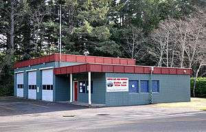 Otter Rock fire station | |
| Nickname(s): The Punch Bowl | |
| Motto(s): “Don’t go inside the Punch Bowl” | |
| Country | United States |
| State | Oregon |
| County | Lincoln |
| Time zone | UTC-8 (PST) |
| • Summer (DST) | UTC-7 (PDT) |
| ZIP codes | 97369 |
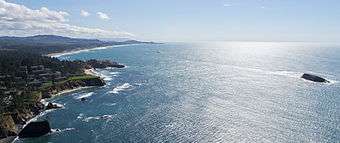
Otter Rock is an unincorporated community in Lincoln County, Oregon, United States. It is located on U.S. Route 101 on the Oregon Coast.
Otter Rock post office was established in 1913, and it takes its name from a rock located about 1⁄2 mile (0.8 km) offshore and 3.25 miles (5.23 km) north of Yaquina Head. Sea otters formerly lived around the rock.[1]
Devils Punch Bowl State Natural Area is located in Otter Rock.
The community's ZIP Code is 97369.
Climate
This region experiences warm (but not hot) and dry summers, with no average monthly temperatures above 71.6 °F (22.0 °C). According to the Köppen Climate Classification system, Otter Rock has a warm-summer Mediterranean climate, abbreviated "Csb" on climate maps.[2]
References
- ↑ McArthur, Lewis A.; Lewis L. McArthur (2003) [1928]. Oregon Geographic Names (Seventh ed.). Portland, Oregon: Oregon Historical Society Press. ISBN 0-87595-277-1.
- ↑ Climate Summary for Otter Rock, Oregon
External links
- Historic photos of Otter Rock from Salem Public Library
- Devil's Punch Bowl State Natural Area from Oregon Parks and Recreation Department
Coordinates: 44°44′50″N 124°03′37″W / 44.74722°N 124.06028°W
Municipalities and communities of Lincoln County, Oregon, United States | ||
|---|---|---|
| Cities | 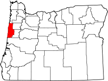 | |
| CDPs | ||
| Unincorporated communities | ||
| Indian reservation | ||
| Footnotes | ‡This populated place also has portions in an adjacent county or counties | |