Ostrovsky District, Kostroma Oblast
| Ostrovsky District Островский район (Russian) | |
|---|---|
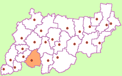 Location of Ostrovsky District in Kostroma Oblast | |
| Coordinates: 57°48′16″N 42°14′28″E / 57.80444°N 42.24111°ECoordinates: 57°48′16″N 42°14′28″E / 57.80444°N 42.24111°E | |
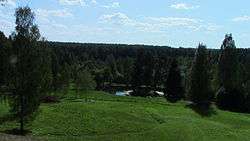 Park Manor Shchelykovo the house-museum of Alexander Ostrovsky, Ostrovsky District | |
.png) |
.png) |
|
| |
| Location | |
| Country | Russia |
| Federal subject | Kostroma Oblast[1] |
| Administrative structure (as of April 2014) | |
| Administrative center | settlement of rural type of Ostrovskoye[1] |
| Administrative divisions:[2] | |
| Settlements | 6 |
| Inhabited localities:[2] | |
| Rural localities | 122 |
| Municipal structure (as of March 2014) | |
| Municipally incorporated as | Ostrovsky Municipal District[3] |
| Municipal divisions:[3] | |
| Urban settlements | 0 |
| Rural settlements | 6 |
| Statistics | |
| Area | 2,720 km2 (1,050 sq mi)[4] |
| Population (2010 Census) | 12,787 inhabitants[5] |
| • Urban | 0% |
| • Rural | 100% |
| Density | 4.7/km2 (12/sq mi)[6] |
| Time zone | MSK (UTC+03:00)[7] |
| Established | 1929[4] |
| Official website | |
| Ostrovsky District on WikiCommons | |
Ostrovsky District (Russian: Остро́вский райо́н) is an administrative[1] and municipal[3] district (raion), one of the twenty-four in Kostroma Oblast, Russia. It is located in the southwest of the oblast. The area of the district is 2,720 square kilometers (1,050 sq mi).[4] Its administrative center is the rural locality (a settlement of rural type) of Ostrovskoye.[1] Population: 12,787 (2010 Census);[5] 14,758 (2002 Census);[8] 17,141 (1989 Census).[9] The population of Ostrovskoye accounts for 39.4% of the district's total population.[5]
Geography
Ostrovsky District is located in the southwest of Kostroma Oblast, about 10km north of the Volga River as it runs west to east. The terrain is flat or slightly hilly, with pine-larch forests (southern taiga) covering much of the district. The terrain is flat to slightly hilly, with a glacier-formed landscape of moraines, swamps, and lakes. The Mera River runs south to the Volga. Ostrovsky District is 50 km east of the regional city of Kostroma, and about 360 km northeast of Moscow. The area measures 65 km (north-south), and 55 km (west-east); total area is 2,446 km2 (about 4% of Kostroma Oblast). The administrative center is the town of Ostrovskkoye.[4]
The district is bordered on the north by Galichsky District, on the east by Antropovsky District and Kadyysky District, on the south by Ivanovo Oblast, and on the west by Sudislavsky District.
History
Ostrovsky District was originally name Semyonovsky District on its founding in 1929. At that time it was part of the Kineshma District of the Ivanovo Industrial Region. It was transferred to Kotroma Oblast in 1944, and renamed Ostrovsky District in 1948. The central town of Ostrovskoye was originally named Semenovskoe-Lapotnoe, with the new name being effected in 1956 to mark the 70th anniversary of the death of the playwright Alexander Ostrovsky.
References
Notes
- 1 2 3 4 Law #112-4-ZKO
- 1 2 Registry of the Inhabited Localities of Kostroma Oblast
- 1 2 3 Law #237-ZKO
- 1 2 3 4 "General Information" (in Russian). Ostrovsky District. Retrieved September 25, 2017.
- 1 2 3 Russian Federal State Statistics Service (2011). "Всероссийская перепись населения 2010 года. Том 1" [2010 All-Russian Population Census, vol. 1]. Всероссийская перепись населения 2010 года (2010 All-Russia Population Census) (in Russian). Federal State Statistics Service. Retrieved June 29, 2012.
- ↑ The value of density was calculated automatically by dividing the 2010 Census population by the area specified in the infobox. Please note that this value is only approximate as the area specified in the infobox does not necessarily correspond to the area of the entity proper or is reported for the same year as the population.
- ↑ Правительство Российской Федерации. Федеральный закон №107-ФЗ от 3 июня 2011 г. «Об исчислении времени», в ред. Федерального закона №271-ФЗ от 03 июля 2016 г. «О внесении изменений в Федеральный закон "Об исчислении времени"». Вступил в силу по истечении шестидесяти дней после дня официального опубликования (6 августа 2011 г.). Опубликован: "Российская газета", №120, 6 июня 2011 г. (Government of the Russian Federation. Federal Law #107-FZ of June 31, 2011 On Calculating Time, as amended by the Federal Law #271-FZ of July 03, 2016 On Amending Federal Law "On Calculating Time". Effective as of after sixty days following the day of the official publication.).
- ↑ Russian Federal State Statistics Service (May 21, 2004). "Численность населения России, субъектов Российской Федерации в составе федеральных округов, районов, городских поселений, сельских населённых пунктов – районных центров и сельских населённых пунктов с населением 3 тысячи и более человек" [Population of Russia, Its Federal Districts, Federal Subjects, Districts, Urban Localities, Rural Localities—Administrative Centers, and Rural Localities with Population of Over 3,000] (XLS). Всероссийская перепись населения 2002 года [All-Russia Population Census of 2002] (in Russian). Retrieved August 9, 2014.
- ↑ Demoscope Weekly (1989). "Всесоюзная перепись населения 1989 г. Численность наличного населения союзных и автономных республик, автономных областей и округов, краёв, областей, районов, городских поселений и сёл-райцентров" [All Union Population Census of 1989: Present Population of Union and Autonomous Republics, Autonomous Oblasts and Okrugs, Krais, Oblasts, Districts, Urban Settlements, and Villages Serving as District Administrative Centers]. Всесоюзная перепись населения 1989 года [All-Union Population Census of 1989] (in Russian). Институт демографии Национального исследовательского университета: Высшая школа экономики [Institute of Demography at the National Research University: Higher School of Economics]. Retrieved August 9, 2014.
Sources
- Костромская областная Дума. Закон №112-4-ЗКО от 9 февраля 2007 г. «Об административно-территориальном устройстве Костромской области», в ред. Закона №567-5-ЗКО от 24 сентября 2014 г. «О внесении изменений в Закон Костромской области "Об административно-территориальном устройстве Костромской области"». Вступил в силу со дня официального опубликования. Опубликован: "СП — нормативные документы", №10(70), 28 февраля 2007 г. (Kostroma Oblast Duma. Law #112-4-ZKO of February 9, 2007 On the Administrative-Territorial Structure of Kostroma Oblast, as amended by the Law #567-5-ZKO of September 24, 2014 On Amending the Law of Kostroma Oblast "On the Administrative-Territorial Structure of Kostroma Oblast". Effective as of the official publication date.).
- Администрация Костромской области. Постановление №133-а от 8 апреля 2014 г. «Об утверждении реестра населённых пунктов Костромской области». Вступил в силу 11 апреля 2014 г. Опубликован: "СП — нормативные документы", №15, 11 апреля 2014 г. (Administration of Kostroma Oblast. Resolution #133-a of April 8, 2014 On the Adoption of the Registry of the Inhabited Localities of Kostroma Oblast. Effective as of April 11, 2014.).
- Костромская областная Дума. Закон №237-ЗКО от 30 декабря 2004 г. «Об установлении границ муниципальных образований в Костромской области и наделении их статусом», в ред. Закона №496-5-ЗКО от 28 февраля 2014 г. «О внесении изменений в Закон Костромской области "Об установлении границ муниципальных образований в Костромской области и наделении их статусом"». Вступил в силу по истечении 10 дней со дня официального опубликования. Опубликован: "Северная Правда" ("Документы: СпецВыпуск"), №8, 26 января 2005 г. (Kostroma Oblast Duma. Law #237-ZKO of December 30, 2004 On the Establishment of the Borders of the Municipal Formations and on Granting Them Statuses, as amended by the Law #496-5-ZKO of February 28, 2014 On Amending the Law of Kostroma Oblast "On the Establishment of the Borders of the Municipal Formations and on Granting Them Statuses". Effective as of after 10 days following the official publication date.).
Administrative center: Kostroma • Rural localities | ||
| Districts | ||
| Cities and towns | ||
| Urban-type settlements |
| |