Ostrožin
| Ostrožin Острожин (Serbian)[1] | |
|---|---|
| Village | |
 Ostrožin Location of Ostrožin in Croatia | |
| Coordinates: 45°25′44″N 15°51′21″E / 45.42889°N 15.85583°E | |
| Country |
|
| Region | Continental Croatia |
| County | Sisak-Moslavina County |
| Municipality | Gvozd |
| Elevation | 184 m (604 ft) |
| Population (2011)[2] | |
| • Total | 32 |
| Time zone | UTC+1 (CET) |
| • Summer (DST) | UTC+2 (CEST) |
| Postal code | 44410 |
| Area code(s) | (+385) 44 |
Ostrožin (Serbian Cyrillic: Острожин)[1] is a village in central Croatia, in the municipality of Gvozd, Sisak-Moslavina County. It is connected by the D6 highway.
History
The Ostrožin Rulebook (Croatian: Ostrožinski pravilnik) was adopted on 14 December 1941 in Ostrožin.[3] Predating the Foča Regulations by more than a month, the Ostrožin Rulebook was the first legal act which regulated the new national authority in the liberated territories during the national liberation war of Yugoslavia.
Demographics
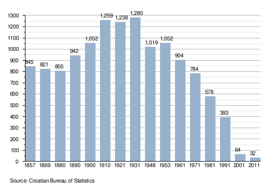
According to the 2011 census,[2] the village of Ostrožin has 32 inhabitants. This represents 8.14% of its pre-war population according to the 1991 census.
According to the 1991 census,[4] 94.91% of the village population were ethnic Serbs (373/393), 0.76% were ethnic Croats (3/393), 0.51% were Yugoslavs (2/393) and 3.82% were of other ethnic origin (15/393).
Population change 1857-2011 [2][5]
Notable natives and residents
- Ognjeslav Utješinović Ostrožinski (1817–1890) - politician and writer
References
- 1 2 Government of Croatia (October 2013). "Peto izvješće Republike Hrvatske o primjeni Europske povelje o regionalnim ili manjinskim jezicima" (PDF) (in Croatian). Council of Europe. p. 36. Retrieved 30 November 2016.
- 1 2 3 "Population by Age and Sex, by Settlements, 2011 Census: Ostrožin". Census of Population, Households and Dwellings 2011. Zagreb: Croatian Bureau of Statistics. December 2012.
- ↑ Branko Žutić, “Razvitak narodne vlasti u kotaru Vrginmost 1941-1943”, Historijski zbornik, pg 81, Naklada Školska knjiga, Zagreb, 1955.
- ↑ Izdanje Državnog zavoda za statistiku RH: Narodnosni sastav stanovništva RH od 1880-1991. godine.
- ↑ Naselja i stanovništvo Republike Hrvatske 1857-2001, www.dzs.hr
Coordinates: 45°25′44″N 15°51′21″E / 45.42889°N 15.85583°E