Osowa Sień
| Osowa Sień | |
|---|---|
| Village | |
 Palace | |
 Osowa Sień | |
| Coordinates: 51°50′16″N 16°20′14″E / 51.83778°N 16.33722°E | |
| Country |
|
| Voivodeship | Lubusz |
| County | Wschowa |
| Gmina | Wschowa |
| Population (2010[1]) | 1,132 |
| Postal code | 67-400 |
| Area code(s) | (+48) 65 |
| Car plates | FWS |
Osowa Sień [ɔˈsɔva ˈɕeɲ] (German: Röhrsdorf)[2] is a village in the administrative district of Gmina Wschowa, within Wschowa County, Lubusz Voivodeship, in western Poland.[3] It lies approximately 5 kilometres (3 mi) north-east of Wschowa and 59 km (37 mi) east of Zielona Góra.
Etymology
The current name of the village is literally a house in the aspen and appears in Polish historical sources also as Ossowa Sień or Ossowasień. The German name is derived from the name of a German settler Rüdiger and occurs in older versions as Rüdigersdorf or later shortened Röhrsdorf.
History
The first mention of the village dates from 1325 and then was called Rudegeri Villa.[4]
Heritage
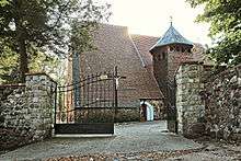

The Church of St. Fabian and St. Sebastian, built in the 14th century, is the oldest historical building in Osowa Sień. It is a single-aisle building, made of stone with a use of bricks. Baroque interior comes from the 18th century. Inside there is as well the sculpture of Christ from the 16th century and the Renaissance tombstones of a former landlords from Żychliński and Ossowski family.[5]
In the village there is also the neoclassical palace complex built between 1890-1904 and Classicist manor from the beginning of the 19th century, both surrounded by large park areas.[5]
Notable residents
- Leonie Ossowski (born Jolanthe von Brandenstein in 1925); author
References
- ↑ http://stat.gov.pl/bdl/app/samorzad_m.dims
- ↑ M. Kaemmerer (2004). Ortsnamenverzeichnis der Ortschaften jenseits von Oder u. Neiße (in German). ISBN 3-7921-0368-0.
- ↑ "Central Statistical Office (GUS) - TERYT (National Register of Territorial Land Apportionment Journal)" (in Polish). 2008-06-01.
- ↑ http://www.osowasien.pro-e.pl/index.php/o-miejscowoci/kalendarium
- 1 2 http://www.osowasien.pro-e.pl/
Bibliography
- Martin Sprungala: Wsie na pograniczu głogowsko-wielkopolskim. Zarys dziejów wybranych miejscowości. Sława - Wijewo 2010, ISBN 978-83-932235-0-3
| Town and seat |  | |
|---|---|---|
| Villages | ||
Coordinates: 51°50′16″N 16°20′14″E / 51.83778°N 16.33722°E