Oryukdo
| Oryukdo | |
| Hangul | 오륙도 |
|---|---|
| Hanja | 五六島 |
| Revised Romanization | Oryukdo |
| McCune–Reischauer | Oryukto |
| Native name: 오륙도 | |
|---|---|
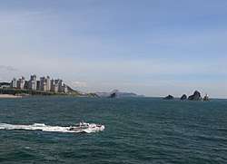 Oryukdo in 2013 | |
 Oryukdo | |
| Geography | |
| Location | Korea Strait |
| Coordinates | 35°05′35″N 129°07′36″E / 35.09306°N 129.12667°ECoordinates: 35°05′35″N 129°07′36″E / 35.09306°N 129.12667°E |
| Total islands | 6 |
| Major islands | Deungdae-seom |
| Area | 28,189 m2 (303,420 sq ft)[1] |
| Highest elevation | 68 m (223 ft)[2] |
| Highest point | Gul-seom[2] |
| Administration | |
| Neighborhood | Yongho-dong |
| District | Nam-gu |
| City | Busan |
Orukdo (literally as Five–Six island) is group of islands located in Yongho-dong, Nam-gu, Busan.
References
- ↑ "부산 오륙도". Cultural Heritage Administration of Korea (in Korean). Retrieved 2015-01-24.
- 1 2 "부산의 상징 '오륙도' 바다 속 대청소" (in Korean). Yonhap News. 2012-03-29. Retrieved 2015-01-24.
This article is issued from
Wikipedia.
The text is licensed under Creative Commons - Attribution - Sharealike.
Additional terms may apply for the media files.