Oruro, Bolivia
| Oruro Uru Uru | |||
|---|---|---|---|
| City | |||
 | |||
| |||
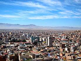
 Oruro Location within Bolivia | |||
| Coordinates: 17°58′S 67°07′W / 17.967°S 67.117°W | |||
| Country | Bolivia | ||
| Department | Oruro Department | ||
| Province | Cercado Province | ||
| Founded | November 1, 1606 | ||
| Government | |||
| • Mayor | Rossío Pimentel | ||
| Area | |||
| • City | 1,633 km2 (631 sq mi) | ||
| Elevation | 3,735 m (12,254 ft) | ||
| Population (2012 Census) | |||
| • Urban | 264,683 | ||
| Time zone | UTC-4 | ||
| Website | Official website | ||


Oruro (Hispanicized spelling) or Uru Uru[1] is a city in Bolivia with a population of 264,683 (2012 calculation),[2] about halfway between La Paz and Sucre in the Altiplano, approximately 3,709 meters (12,169 ft) above sea level.
It is Bolivia's fifth-largest city by population, after Santa Cruz de la Sierra, El Alto, La Paz, and Cochabamba. It is the capital of the department of Oruro and the seat of the Roman Catholic Diocese of Oruro. Oruro has been subject to cycles of boom and bust owing to its dependence on the mining industry, notably tin, tungsten (wolfram), silver and copper.
History
The city was founded on November 1, 1606, by Don Manuel Castro de Padilla. as a silver-mining center in the Urus region. At the time it was named Real Villa de San Felipe de Austria, after the Spanish monarch Philip III. It thrived for a while, but it was eventually abandoned as the silver mines became exhausted.[3]
Oruro was reestablished by European Bolivians in the late nineteenth century as a tin mining center.[4] It was named after the native tribe Uru-Uru. For a time, the La Salvadora tin mine was the most important source of tin in the world. Gradually, as this resource became less plentiful, Oruro again went into a decline. Its economy is still based on the mining industry.[4]
Economy
While traditionally based upon mining, Oruro has become increasingly popular for tourism since the late 20th century. In the early 21st century, Oruro's economy grew through trade and economic connections with Chile, especially for exporting products to Pacific markets. It transported products by road through Chile to the Pacific port of Iquique to open new connections to external markets; it also used the rail connection through Uyuni to the port at Antofagasta for exports.[5] Thanks to increased road building, Oruro has become important as a waystation on the overland route of goods from the Atlantic port of Santos, Brazil, through Puerto Suárez and Santa Cruz to the capital, La Paz.[6]
Culture and education
Despite its economic decline, the city attracts numerous tourists to its Carnaval de Oruro, considered one of the great folkloric events in South America for its masked "diablada"[7] and Anata.[8]
.JPG)
The Oruro Symphony Orchestra is based in the city. Aymara painter and printmaker Alejandro Mario Yllanes (1913–1960) was born here.[9]
The Universidad Técnica de Oruro, noted for its engineering school, is located in Oruro.[10]
Climate

Oruro lies north of the salty lakes Uru Uru and Poopó. It is three hours (by bus) from La Paz. Located at an altitude of 3709 meters above sea level, Oruro is well known for its cold weather. Warmer temperatures generally take place during August, September and October, after the worst of the winter chills and before the summer rains. From May to early July, night time temperatures combined with cool wind can bring the temperature down to about -20 °C. Summers are warmer, and, although it is an arid area, it has considerable rainfall between November and March. The Köppen Climate System describes the climate as Tropical and Subtropical Steppe, abbreviated BSk.[11] Due to the warm days and dry winters, snow is not a frequent occurrence as much as the bitter cold (especially at night); however, flurries can fall usually once every few years, most recently July 4, 2015.[12] The other three most recent snowfalls were those of 13 June 2013,[13] 1 September 2010 (with accumulation),[14] as well as one in 2008.
| Climate data for Oruro | |||||||||||||
|---|---|---|---|---|---|---|---|---|---|---|---|---|---|
| Month | Jan | Feb | Mar | Apr | May | Jun | Jul | Aug | Sep | Oct | Nov | Dec | Year |
| Average high °C (°F) | 16 (61) |
15 (59) |
16 (61) |
16 (61) |
16 (61) |
15 (59) |
15 (59) |
16 (61) |
17 (63) |
19 (66) |
19 (66) |
17 (63) |
16 (62) |
| Average low °C (°F) | 3 (37) |
2 (36) |
2 (36) |
0 (32) |
−3 (27) |
−6 (21) |
−5 (23) |
−4 (25) |
−1 (30) |
0 (32) |
2 (36) |
3 (37) |
−1 (31) |
| Average precipitation mm (inches) | 94 (3.7) |
84 (3.3) |
51 (2.0) |
15 (0.6) |
5 (0.2) |
3 (0.1) |
3 (0.1) |
10 (0.4) |
15 (0.6) |
15 (0.6) |
33 (1.3) |
64 (2.5) |
392 (15.4) |
| Source: Weatherbase [15] | |||||||||||||
Main attractions

- Museo Patiño, former residence of "tin baron" Simón Iturri Patiño
- Museo Mineralógico (Mineralogical Museum): has exhibits of precious stones, minerals, and fossils
- Museo Etnográfico Minero (Ethnographical Mining Museum): housed in a mine tunnel, depicts methods of Bolivian mining
- Museo Nacional Antropológico Eduardo López Rivas (National Anthropological Museum): displays tools and information on the Chipaya and Uru tribes, and about Carnaval de Oruro.
- Churches: Catedral Nuestra Señora de la Asunción, Santuario de la Virgen del Socavón, Iglesia de Cunchupata
- Inti Raymi, a mine
Education
Because of a high proportion of German-speaking residents, many of whom came as immigrants to work in the mines, the area once had a German school, Deutsche Schule Oruro.[16]
Twin cities
Notable people from Oruro
- Elsa Cladera de Bravo (1922—2005) Trade union leader
See also
References
- ↑ Yaticha Kamani / Ministerio de Educación, Aymara aru thakhinchawi, Chuqi Yapu 2011
- ↑ "World Gazetteer". World-Gazetteer.com. Archived from the original on 13 May 2012. Retrieved 23 April 2017.
- ↑ Oscar Cornblit. Power and Violence in the Colonial City: Oruro from the Mining Renaissance to the Rebellion of Tupac Amaru (1740-1782). Trans. Elizabeth Ladd Glick. New York: Cambridge University Press 1995.
- 1 2 "Oruro: History". Lonely Planet.
- ↑ Ancalle, Milka Ruth Cayoja (2012). Oruro Como Centro Estratégico Comercial Internacional de Bolivia: Competitividad y Consecuencias del Proceso (PDF). (Master's Thesis, Pontifical Catholic University of Chile). Institute of Urban and Regional Studies, Pontifical Catholic University of Chile. Archived from the original (PDF) on 8 February 2014. Retrieved 8 February 2014.
- ↑ Ancalle 2012, p. 27
- ↑ Kartomi, Margaret Joy & Blum, Stephen (1994). Music-Cultures In Contact: Convergences And Collisions. Basel, Switzerland: Gordon and Breach. p. 63. ISBN 978-2-88449-137-2.
- ↑ G. N. Devy, Geoffrey V. Davis, K. K. Chakravarty, Knowing Differently: The Challenge of the Indigenous, ISBN 1317325680 (2015). Quote: "The Anata is a festivity celebrated since the early 1990s in the city of Oruro, but it is linked to pre-Hispanic agricultural practices in the rural highlands related to fertility. The most public expression of the Anata in Oruro is a danced parade that is ..."
- ↑ Raynor, Vivien. ART; "Works by a Vanished Bolivian Painter", New York Times. 5 April 1992 (retrieved 2 May 2009)
- ↑ "Official Facultad Nacional de Ingeniería (National Engineering School) webpage" (in Spanish). Archived from the original on 2006-10-05. Retrieved 2006-11-24.
- ↑ "Oruro, Bolivia Köppen Climate Classification (Weatherbase)". weatherbase.com. Retrieved 23 April 2017.
- ↑ "La Paz, El Alto y Oruro se visten de blanco por densa nevada". Periodico del Estado Nacional de Bolivia CAMBIO. Archived from the original on 2015-07-16. Retrieved 2015-07-16.
- ↑ "Después de tres años nevó en la ciudad de Oruro". La Patria.
- ↑ "Nieve, nubosidad y lluvia primaron en la última jornada". La Patria.
- ↑ "Weatherbase: Historical Weather for Oruro". Weatherbase. 2011. Retrieved on November 24, 2011.
- ↑ "Deutscher Bundestag 4. Wahlperiode Drucksache IV/3672" (Archived 2016-03-12 at WebCite). Bundestag (West Germany). 23 June 1965. Retrieved on 12 March 2016. p. 18/51.
- ↑ "Archived copy". Archived from the original on 2013-06-02. Retrieved 2013-02-06.
External links
| Wikimedia Commons has media related to Oruro. |
| Wikivoyage has a travel guide for Oruro. |
- Oruro's full information about hotels, history, carnival, tourism, pictures, videos, and news
- Weather in Oruro
- Carnaval de Oruro
- [http://www.micarnaval.net Oruro's Carnival]
- Oruro's Carnival
- Oruro
Coordinates: 17°58′S 67°07′W / 17.967°S 67.117°W
Capital: Oruro | ||
| Provinces | 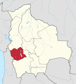 | |
| Municipalities (and seats) |
| |