Oruanui eruption
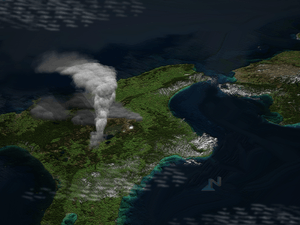
The Oruanui eruption of New Zealand's Taupo Volcano, the world's most recent supereruption, had a Volcanic Explosivity Index of 8. It is one of the largest eruptions in the history of New Zealand. It occurred about 26,500 years ago in the Late Pleistocene and generated approximately 430 km3 (100 cu mi) of pyroclastic fall deposits, 320 km3 (77 cu mi) of pyroclastic density current (PDC) deposits (mostly ignimbrite) and 420 km3 (100 cu mi) of primary intracaldera material, equivalent to 530 km3 (130 cu mi) of magma, totaling 1,170 km3 (280 cu mi) of total deposits. The eruption is divided into 10 different phases on the basis of nine mappable fall units and a tenth, poorly preserved but volumetrically dominant fall unit.[1][2][3][4]
Modern-day Lake Taupo (616 km2 (238 sq mi) and 186 m deep) partly fills the caldera generated during this eruption. A 140 km2 (54 sq mi) structural collapse is concealed beneath Lake Taupo, while the lake outline at least partly reflects volcano-tectonic collapse. Early eruption phases saw shifting vent positions; development of the caldera to its maximum extent (indicated by lithic lag breccias) occurred during phase 10.
The Oruanui eruption shows many unusual features: its episodic nature, wide range of depositional conditions in fall deposits of very wide dispersal, and complex interplay of falls and pyroclastic flows.
Tephra from the eruption covered much of the central North Island, with ignimbrite up to 200 metres (660 ft) deep. Ashfall affected most of New Zealand, with even an 18 cm (7 in) ash layer deposited on the Chatham Islands, 1,000 km (620 mi) away. Later erosion and sedimentation had long-lasting effects on the landscape, and caused the Waikato River to shift from the Hauraki Plains to its current course through the Waikato to the Tasman Sea.
See also
- North Island Volcanic Plateau
- Hatepe eruption (Taupo Volcano, circa 180 AD)
References
- ↑ Wilson, C. J. N. (2001). "The 26.5ka Oruanui eruption, New Zealand: An introduction and overview". Journal of Volcanology and Geothermal Research. 112: 133. doi:10.1016/S0377-0273(01)00239-6.
- ↑ Manville, V.; Wilson, C. J. N. (2004). "The 26.5 ka Oruanui eruption, New Zealand: A review of the roles of volcanism and climate in the post‐eruptive sedimentary response". New Zealand Journal of Geology and Geophysics. 47 (3): 525. doi:10.1080/00288306.2004.9515074.
- ↑ Wilson, C. J. N. (2005). "The 26.5 ka Oruanui Eruption, Taupo Volcano, New Zealand: Development, Characteristics and Evacuation of a Large Rhyolitic Magma Body". Journal of Petrology. 47: 35. doi:10.1093/petrology/egi066.
- ↑ Richard Smith, David J. Lowe and Ian Wright. 'Volcanoes - Lake Taupo', Te Ara - the Encyclopedia of New Zealand, updated 16-Apr-2007.