Orion (satellite)
.jpg)


Orion, also known as Mentor or Advanced Orion,[1] is a class of United States spy satellites that collect signals intelligence (SIGINT) from space. Operated by the National Reconnaissance Office (NRO) and developed with input from the Central Intelligence Agency (CIA), five have been launched from Cape Canaveral on Titan IV and Delta IV rockets since 1995.
These satellites collect radio emissions (SIGINT) from geostationary orbits and act as replacements for the older constellation of Magnum satellites. Observers estimate the satellites weigh close to 5,200 kg and have very large (estimated 100 m diameter)[2] radio reflecting dishes. NRO L-32, which is seen as the fifth satellite in the series, is according to NRO director Bruce Carlson "(...) the largest satellite in the world".[3] It is believed that this refers to the diameter of the main antenna, which might be well in excess of 100 m (330 ft).[4] The mission and capabilities of these satellites are highly classified, though targets may include telemetry, VHF radio, cellular mobile phones, paging signals, and mobile data links.[5] Earlier satellites with similar missions, the Rhyolite/Aquacade series, were built by TRW; it is not known who made the Orion satellites.[6]
Satellites
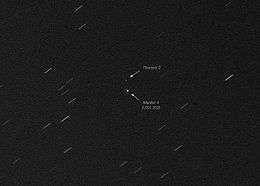
MENTOR 4 (USA-202) deployment and initial westward drift after launch in January 2009 was controlled by the Alice Springs Mission Ground Station. About 60 days after launch Menwith Hill Ground Station was to take over control, and initiate the collection mission. MENTOR 4's initial mission was to survey line-of-sight microwave towers and emitters in the People's Republic of China for 30 to 45 days as it was drifting from east to west. Moving further west, it was to collect data from the Thuraya network, and monitor Pakistan and Afghanistan, followed by another 200 days of monitoring of the PRC. This was to be followed by data collection covering the middle East, Northern Africa, and Latin America.[7][8]
| Name | COSPAR ID SATCAT № |
Launch date (UTC) |
Launch vehicle | Launch site | Launch designation | Longitude | Remarks |
|---|---|---|---|---|---|---|---|
| USA-110 | 1995-022A | 14 May 1995 13:45:01 | Titan IV(401)A | CCAFS SLC-40 | N/A | 127°E[4] | MENTOR 1[1] |
| USA-139 | 1998-029A | 9 May 1998 01:38:01 | Titan IV(401)B | CCAFS SLC-40 | NROL-6 | 44°E (1998–2009) 14.5°W (2009—)[4] | MENTOR 2[1] |
| USA-171 | 2003-041A | 9 September 2003 04:29:00 | Titan IV(401)B | CCAFS SLC-40 | NROL-19 | 95.5°E[4] | MENTOR 3[1] |
| USA-202 | 2009-001A | 18 January 2009 02:47 | Delta IV Heavy | CCAFS SLC-37B | NROL-26 | 44°E[4] | MENTOR 4[1] |
| USA-223 | 2010-063A | 21 November 2010 22:58:00 | Delta IV Heavy | CCAFS SLC-37B | NROL-32 | 100.9°E[9] | MENTOR 5[1] |
| USA-237 | 2012-034A | 29 June 2012 13:15 | Delta IV Heavy | CCAFS SLC-37B | NROL-15 | MENTOR 6[1] | |
| USA-268 | 2016-036A | 11 June 2016 17:51 | Delta IV Heavy | CCAFS SLC-37B | NROL-37 | MENTOR 7[1] | |
References
- 1 2 3 4 5 6 7 8 Justin Ray (11 June 2016). "Triple-barrel Delta 4-Heavy launches national security satellite". Spaceflight Now. Retrieved 12 June 2016.
- ↑ Spy satellites of the NSA (fr)
- ↑ Bruce Carlson (2010-09-13). "National Reconnaissance Office Update" (PDF). Air & Space Conference and Technology Exposition 2010. Retrieved 2010-11-25.
- 1 2 3 4 5 William Graham (2010-11-21). "Delta IV Heavy launches with NROL-32". nasaspaceflight.com. Retrieved 2010-11-22.
- ↑ Campbell, Duncan (April 1999). "STOA Report: Interception Capabilities 2000".
- ↑ Jonathan's space report No. 369 (1998-08-22)
- ↑ "Two New Collection Assets to Greatly Expand MHS Target Coverage". National Security Agency. 2009-01-05. Retrieved 2017-05-04.
- ↑ Marco Langbroek (31 October 2016). "A NEMESIS in the sky: PAN, MENTOR 4, and close encounters of the SIGINT kind". The Space Review. Retrieved 5 May 2017.
- ↑ T. Flohrer; R. Choc & B. Bastida (February 2011). "CLASSIFICATION OF GEOSYNCHRONOUS OBJECTS ISSUE 13" (PDF). ESA. Archived from the original (PDF) on 2011-07-13.
External links
- Advanced Orion at Encyclopedia Astronautica
- Magnum/ Mentor/ Orion at Globalsecurity.org
- The USA 202 ORION satellite
| IMINT |
| ||||||||
|---|---|---|---|---|---|---|---|---|---|
| SIGINT |
| ||||||||
| MASINT |
| ||||||||
| Research and development |
| ||||||||
| Unknown |
| ||||||||