Oreini, Elis
| Oreini Ορεινή | |
|---|---|
 | |
 Oreini | |
| Coordinates: 37°52′N 21°51′E / 37.867°N 21.850°ECoordinates: 37°52′N 21°51′E / 37.867°N 21.850°E | |
| Country | Greece |
| Administrative region | West Greece |
| Regional unit | Elis |
| Municipality | Archaia Olympia |
| Municipal unit | Lampeia |
| Population (2011)[1] | |
| • Rural | 194 |
| Community[1] | |
| • Population | 206 (2011) |
| Time zone | UTC+2 (EET) |
| • Summer (DST) | UTC+3 (EEST) |
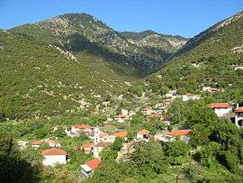
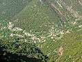
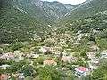
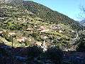
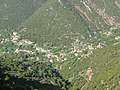
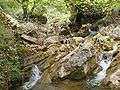
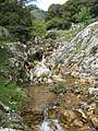
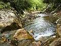
Oreini (Greek: Ορεινή meaning "mountainous", before 1928: Μποστενίτσα - Bostenitsa[2]) is a mountain village and a community in the municipal unit of Lampeia, Elis, Greece. Oreini is built on the slopes of Mount Lampeia, part of the Erymanthos range. The community Oreini consists of the villages Oreini and Paliofytia. The population in 2011 was 194 for the village and 206 for the community. Oreini is located 4 km east of Lampeia, 4 km west of Psofida, 6 km south of Agrampela and 32 km northeast of Olympia. The former name of the village, Bostenitsa, suggests a Slavic origin. The revolutionary leader Theodoros Papasimakopoulos, who fought in the Greek War of Independence, was from Bostenitsa.
Gallery
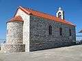 Church of Agios Ioannis
| Wikimedia Commons has media related to Oreini, Ilia. |
See also
External links
References
- 1 2 "Απογραφή Πληθυσμού - Κατοικιών 2011. ΜΟΝΙΜΟΣ Πληθυσμός" (in Greek). Hellenic Statistical Authority.
- ↑ Name changes of settlements in Greece
This article is issued from
Wikipedia.
The text is licensed under Creative Commons - Attribution - Sharealike.
Additional terms may apply for the media files.