Oregon Route 422
| ||||
|---|---|---|---|---|
 | ||||
| Route information | ||||
| Maintained by ODOT | ||||
| Length | 5.29 mi[1] (8.51 km) | |||
| Existed | 2002 – present | |||
| Major junctions | ||||
| West end | Modoc Point Road near Klamath Agency | |||
|
| ||||
| East end |
| |||
| Highway system | ||||
| ||||

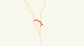
Oregon Route 422 (OR 422) is an Oregon state highway running from Modoc Point Road near Klamath Agency to US 97 near Chiloquin. OR 422 is known as the Chiloquin Highway No. 422[2] (see Oregon highways and routes). It is 5 miles (8.0 km) long and runs east–west, entirely within Klamath County.
OR 422 was established in 2002 as part of Oregon's project to assign route numbers to highways that previously were not assigned.[3] Sometime before June 2007, an OR 422 shield was placed at the end of the off-ramp from NB US 97, but the rest of the route was still unsigned at that time.
OR 422 has an unsigned spur in Chiloquin, which runs 0.19 miles (0.31 km).[4]
Route description
OR 422 begins at an intersection with Modoc Point Road approximately one mile south of Klamath Agency and heads east, crossing OR 62 0.16 miles (0.26 km) east of the start of the route.[5] OR 422 then continues east, crossing US 97 approximately 1-mile (1.6 km) west of Chiloquin and turning southeast into Chiloquin.[5][6] At the intersection of Chocktoot Street and Chiloquin Road in Chiloquin, OR 422S heads southeast along Chocktoot Street and OR 422 turns southwest along Chiloquin Road, ending at an intersection with US 97 approximately 0.60 miles (0.97 km) beyond the city limits.[6]
History
The Chiloquin Highway No. 422 was approved for designation as a secondary highway on November 13, 1931. It was designated on December 6, 1933.[7] The OR 422 designation was applied to the Chiloquin Highway on May 14, 2002.[3]
Major intersections
The entire route is in Klamath County.
| Location | mi[1] | km | Destinations | Notes | |
|---|---|---|---|---|---|
| | 0.00 | 0.00 | Modoc Point Road | ||
| | 0.16 | 0.26 | |||
| | 3.30 | 5.31 | Interchange | ||
| Chiloquin | 4.39 | 7.07 | |||
| | 5.29 | 8.51 | |||
| 1.000 mi = 1.609 km; 1.000 km = 0.621 mi | |||||
Spur route
| |
|---|---|
| Location | Chiloquin, Oregon |
| Length | 0.19 mi[4] (0.31 km) |
| Existed | 2002–present |
Oregon Route 422S (OR 422S) is a spur route of OR 422 in Chiloquin. OR 422S is known as the Chiloquin Spur No. 488.[2] OR 422S begins at the intersection of Chocktoot Street and Chiloquin Road in Chiloquin and heads southeast, ending just past the Williamson River.[6]
References
- 1 2 Oregon Department of Transportation, Public Road Inventory (primarily the Digital Video Log), "Archived copy". Archived from the original on 2008-02-24. Retrieved 2008-03-01. , accessed January 2014.
- 1 2 Oregon Department of Transportation, Routes / State Highway Cross Reference Table, http://www.oregon.gov/ODOT/TD/TDATA/Pages/otms/Route_Hwy_CrossRef.aspx, accessed January 2014.
- 1 2 Oregon Department of Transportation, Descriptions of US and Oregon Routes, http://www.oregon.gov/ODOT/HWY/TRAFFIC-ROADWAY/docs/pdf/Descriptions_of_US_and_Oregon_Routes.pdf, page 31.
- 1 2 Oregon Department of Transportation, Chiloquin Spur Highway No. 488 Straightline Chart, http://www.oregon.gov/ODOT/TD/TDATA/rics/docs/Straightline_Charts/slchart_pdfs/Hwy488.pdf, accessed January 2014.
- 1 2 Oregon Department of Transportation, Chiloquin Highway No. 422 Straightline Chart, http://www.oregon.gov/ODOT/TD/TDATA/rics/docs/Straightline_Charts/slchart_pdfs/Hwy422.pdf
- 1 2 3 Oregon Department of Transportation, Chiloquin City Map, archived from the original on October 7, 2006
- ↑ "History of State Highways in Oregon" (PDF). Oregon Department of Transportation. 2011. pp. 523–524. Retrieved February 6, 2014.
Route map: