Ordinsky District
| Ordinsky District Ординский район (Russian) | |
|---|---|
.svg.png) Location of Ordinsky District in Perm Krai | |
| Coordinates: 57°02′N 56°33′E / 57.033°N 56.550°ECoordinates: 57°02′N 56°33′E / 57.033°N 56.550°E | |
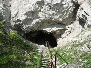 The entrance to the Orda Cave, the largest underwater gypsum cave in the world located in Ordinsky District | |
.gif) |
.png) |
|
| |
| Location | |
| Country | Russia |
| Federal subject | Perm Krai[1] |
| Administrative structure (as of July 2015) | |
| Administrative center | selo of Orda[1] |
| Inhabited localities:[1] | |
| Rural localities | 45 |
| Municipal structure (as of March 2013) | |
| Municipally incorporated as | Ordinsky Municipal District[2] |
| Municipal divisions:[2] | |
| Urban settlements | 0 |
| Rural settlements | 5 |
| Statistics | |
| Area (municipal district) | 1,418 km2 (547 sq mi)[3] |
| Population (2010 Census) | 15,605 inhabitants[4] |
| • Urban | 0% |
| • Rural | 100% |
| Density | 11/km2 (28/sq mi)[5] |
| Time zone | YEKT (UTC+05:00)[6] |
| Established |
February 26, 1924 (first)[3] January 12, 1965 (second)[3] |
| Official website | |
| Ordinsky District on WikiCommons | |
| 2010 Census | 15,605[4] |
|---|---|
| 2002 Census | 17,077[7] |
| 1989 Census | 17,576[8] |
| 1979 Census | 19,300[9] |
Ordinsky District (Russian: Орди́нский райо́н) is an administrative district (raion) of Perm Krai, Russia; one of the thirty-three in the krai.[1] Municipally, it is incorporated as Ordinsky Municipal District.[2] It is located in the southeast of the krai, mostly in the valley of the Iren River. The area of the district is 1,418 square kilometers (547 sq mi).[3] Its administrative center is the rural locality (a selo) of Orda.[1] As of the 2010 Census, the total population of the district was 15,605, with the population of Orda accounting for 34.4% of that number.[4]
History
The district was established on February 26, 1924 and became a part of Perm Oblast in October 1938.[3] It was abolished on February 1, 1963 and restored on January 12, 1965.[3]
Demographics
Ethnic composition:[3]
Economy
The economy of the district is based on agriculture and petroleum industry.
Landmarks
The Orda Cave, one of the longest underwater caves and the largest underwater gypsum cave in the world, is located in Ordinsky District. [10]
References
Notes
- 1 2 3 4 5 Law #416-67
- 1 2 3 Law #1749-360
- 1 2 3 4 5 6 7 Encyclopedia of Perm Krai. Entry on Ordinsky District (in Russian)
- 1 2 3 Russian Federal State Statistics Service (2011). "Всероссийская перепись населения 2010 года. Том 1" [2010 All-Russian Population Census, vol. 1]. Всероссийская перепись населения 2010 года (2010 All-Russia Population Census) (in Russian). Federal State Statistics Service. Retrieved June 29, 2012.
- ↑ The value of density was calculated automatically by dividing the 2010 Census population by the area specified in the infobox. Please note that this value is only approximate as the area specified in the infobox does not necessarily correspond to the area of the entity proper or is reported for the same year as the population.
- ↑ Правительство Российской Федерации. Федеральный закон №107-ФЗ от 3 июня 2011 г. «Об исчислении времени», в ред. Федерального закона №271-ФЗ от 03 июля 2016 г. «О внесении изменений в Федеральный закон "Об исчислении времени"». Вступил в силу по истечении шестидесяти дней после дня официального опубликования (6 августа 2011 г.). Опубликован: "Российская газета", №120, 6 июня 2011 г. (Government of the Russian Federation. Federal Law #107-FZ of June 31, 2011 On Calculating Time, as amended by the Federal Law #271-FZ of July 03, 2016 On Amending Federal Law "On Calculating Time". Effective as of after sixty days following the day of the official publication.).
- ↑ Russian Federal State Statistics Service (May 21, 2004). "Численность населения России, субъектов Российской Федерации в составе федеральных округов, районов, городских поселений, сельских населённых пунктов – районных центров и сельских населённых пунктов с населением 3 тысячи и более человек" [Population of Russia, Its Federal Districts, Federal Subjects, Districts, Urban Localities, Rural Localities—Administrative Centers, and Rural Localities with Population of Over 3,000] (XLS). Всероссийская перепись населения 2002 года [All-Russia Population Census of 2002] (in Russian). Retrieved August 9, 2014.
- ↑ Demoscope Weekly (1989). "Всесоюзная перепись населения 1989 г. Численность наличного населения союзных и автономных республик, автономных областей и округов, краёв, областей, районов, городских поселений и сёл-райцентров" [All Union Population Census of 1989: Present Population of Union and Autonomous Republics, Autonomous Oblasts and Okrugs, Krais, Oblasts, Districts, Urban Settlements, and Villages Serving as District Administrative Centers]. Всесоюзная перепись населения 1989 года [All-Union Population Census of 1989] (in Russian). Институт демографии Национального исследовательского университета: Высшая школа экономики [Institute of Demography at the National Research University: Higher School of Economics]. Retrieved August 9, 2014.
- ↑ "Всесоюзная перепись населения 1979 г. Национальный состав населения по регионам России. (All Union Population Census of 1979. Ethnic composition of the population by regions of Russia.)". Всесоюзная перепись населения 1979 года (All-Union Population Census of 1979) (in Russian). Demoscope Weekly (website of the Institute of Demographics of the State University—Higher School of Economics. 1979. Retrieved 2008-11-25.
- ↑ Sinha, Sanskrity (June 28, 2011). "World's longest underwater 'crystal' cave in deep Russian waters revealed (PHOTOS)". International Business Times. Retrieved October 24, 2017.
Sources
- Законодательное собрание Пермской области. Закон №416-67 от 28 февраля 1996 г. «Об административно-территориальном устройстве Пермского края», в ред. Закона №504-ПК от 9 июля 2015 г. «О внесении изменений в Закон Пермской области "Об административно-территориальном устройстве Пермского края"». Вступил в силу с момента опубликования. Опубликован: "Звезда", №38, 12 марта 1996 г. (Legislative Assembly of Perm Oblast. Law #416-67 of February 28, 1996 On the Administrative-Territorial Structure of Perm Krai, as amended by the Law #504-PK of July 9, 2015 On Amending the Law of Perm Oblast "On the Administrative-Territorial Structure of Perm Krai". Effective as of the moment of publication.).
- Законодательное собрание Пермской области. Закон №1749-360 от 10 ноября 2004 г. «Об утверждении границ и о наделении статусом муниципальных образований Ординского района Пермского края», в ред. Закона №175-ПК от 7 марта 2013 г. «О внесении изменений в отдельные Законы Пермской области, Коми-Пермяцкого автономного округа об утверждении границ и о наделении статусом муниципальных образований Пермского края». Вступил в силу через десять дней со дня официального опубликования. Опубликован: "Бюллетень Законодательного Собрания и администрации Пермской области", №12, I часть, 9 декабря 2004 г. (Legislative Assembly of Perm Oblast. Law #1749-360 of November 10, 2004 On Establishing the Borders and on Granting the Status to the Municipal Formations of Ordinsky District of Perm Krai, as amended by the Law #175-PK of March 7, 2013 On Amending Various Laws of Perm Oblast, Komi-Permyak Autonomous Okrug on Establishing the Borders and on Granting the Status to the Municipal Formations of Perm Krai. Effective as of the day which is ten days following the day of the official publication.).
| Administrative districts | |||
|---|---|---|---|
| Administrative districts of Komi-Permyak Okrug | |||
| Closed administrative-territorial formations | |||
| Cities and towns (all levels) | |||
| Urban-type settlements | |||