Opphaug
| Opphaug | |
|---|---|
| Village | |
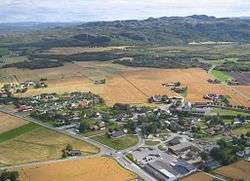 View of the village | |
 Opphaug Location of the village  Opphaug Opphaug (Norway) | |
| Coordinates: 63°43′38″N 9°41′20″E / 63.7273°N 09.6888°ECoordinates: 63°43′38″N 9°41′20″E / 63.7273°N 09.6888°E | |
| Country | Norway |
| Region | Central Norway |
| County | Trøndelag |
| District | Fosen |
| Municipality | Ørland |
| Area[1] | |
| • Total | 0.42 km2 (0.16 sq mi) |
| Elevation[2] | 12 m (39 ft) |
| Population (2017)[1] | |
| • Total | 400 |
| • Density | 952/km2 (2,470/sq mi) |
| Time zone | UTC+01:00 (CET) |
| • Summer (DST) | UTC+02:00 (CEST) |
| Post Code | 7140 Opphaug |
Opphaug is a village in the municipality of Ørland in Trøndelag county, Norway. The village is located on the Ørlandet peninsula about 4 kilometres (2.5 mi) east of the village of Uthaug, 5 kilometres (3.1 mi) northwest of the villages of Ottersbo and Austrått, and 5 kilometres (3.1 mi) northeast of the town of Brekstad.
The 0.42-square-kilometre (100-acre) village has a population (2017) of 400 which gives the village a population density of 952 inhabitants per square kilometre (2,470/sq mi).[1] Opphaug has small-scale industry and a grain mill.[3]
References
- 1 2 3 Statistisk sentralbyrå (1 January 2017). "Urban settlements. Population and area, by municipality".
- ↑ "Opphaug, Ørland (Trøndelag)". yr.no. Retrieved 2018-02-24.
- ↑ Haugen, Morten, ed. (2017-08-20). "Opphaug". Store norske leksikon (in Norwegian). Kunnskapsforlaget. Retrieved 2018-02-19.
This article is issued from
Wikipedia.
The text is licensed under Creative Commons - Attribution - Sharealike.
Additional terms may apply for the media files.