Omeonga
Omeonga is a town in the Sankuru District, Kasai-Oriental, Democratic Republic of the Congo. It lies around 25 miles (40 km) south southeast of the nearest large town, Katako-Kombe. The Lomami river also passes nearby.
Chiefs or possessors of the name Omeonga are considered royal. It is also a name meaning "Man of Pillars" or "Noble".
Impact crater
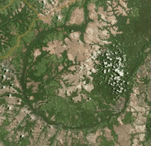
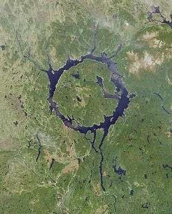
The town lies near the center of a 30 km diameter depression, which is a proposed but unconfirmed ancient impact crater called the "Wembo-Nyama ring structure".[1][2][3] The roundness of the ring is underlined by a tributary of the Lomami river.[4] A similar visual effect can be seen with Manicouagan crater in central Quebec, Canada, where a ring of water surrounds the central René-Levasseur Island.
See also
References
- ↑ "Ring may be giant 'impact crater'". BBC News. 2010-03-10. Retrieved 2010-05-08.
- ↑ G. Monegato; M. Massironi & E. Martellato (2010). "The Ring Structure of Wembo-Nyama (Eastern Kasai, R.D. Congo): A Possible Impact Crater in Central Africa" (PDF). Lunar and Planetary Science. Lunar and Planetary Institute. XLI.
- ↑ The Full Catalogue of the Earth's Impact structures Archived 2009-07-16 at the Wayback Machine.. Siberian Center For Global Catastrophes. Department of Mathematical Problems of Geophysics, Institute of Computational Mathematics and Mathematical Geophysics. Siberian Division, Russian Academy of Sciences.
- ↑ E. Martellato; G. Cremonese; M. Massironi; and G. Monegato (2010). Omeonga (Wembo-Nyama): Isale Hydrocode Simulations, Nördlingen Ries Crater Workshop
External links
Coordinates: 03°28′0″S 24°24′0″E / 3.46667°S 24.40000°E