Omberg
| Omberg | |
|---|---|
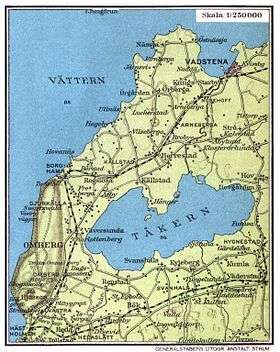 1928 map of the Omberg area. | |
| Highest point | |
| Elevation | 262.8 m (862 ft) |
| Coordinates | 58°18′01″N 14°38′51″E / 58.30028°N 14.64750°ECoordinates: 58°18′01″N 14°38′51″E / 58.30028°N 14.64750°E |
| Geography | |
 Omberg | |
| Geology | |
| Age of rock | Paleoproterozoic |
| Mountain type | Granite horst |
Omberg is forested mountain in the western Östergötland County. It lies between Lake Vättern and Lake Tåkern. Geologically the mountain is horst. Alvastra Abbey lies at its foot.
The western cliff of Omberg has been indicated as a ättestupa in folk history.
Geologically Omberg is horst, a fault-bounded and uplifted block of bedrock.[1]
References
- ↑ Lundqvist, Jan (1969). "Landskapet". In Lundqvist, Magnus. Det Moderna Sverige (in Swedish). Bonniers. p. 44.
This article is issued from
Wikipedia.
The text is licensed under Creative Commons - Attribution - Sharealike.
Additional terms may apply for the media files.