Omak Rock
| Balancing rock | |
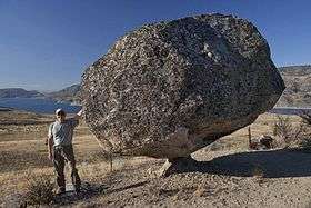 Omak Rock with Omak Lake in the background | |
| Coordinates | 48°14′06″N 119°22′02″W / 48.23507°N 119.36731°WCoordinates: 48°14′06″N 119°22′02″W / 48.23507°N 119.36731°W |
|---|---|
| Composition | |
| Granite | |
Omak Rock, also known as Balance Rock,[1][2] is a balancing rock in the Colville Indian Reservation, in the U.S. state of Washington. Located within the Greater Omak Area of the Okanogan Country, the glacial erratic is about 1,340 feet (410 m) from Omak Lake.[3][4] It is positioned within the vicinity of the 1872 North Cascades earthquake, which it survived. The fact of its survival has been the basis of studies to help determine the acceleration and intensity of the quake. Some believe that the epicenter of the earthquake may have been very close to Omak Rock.[5] The Confederated Tribes of the Colville Reservation believe that the rock represents a symbol of nature's perfection in the region.[6]
References
- ↑ Irwin, Mike (April 6, 2010). "Geology field trip: Balance Rock". The Wenatchee World.
- ↑ "Graphical Locater Result". Montana State University. Retrieved January 1, 2013.
- ↑ Camp, Al; Thew, Chris; Camp, Dee (September 5, 2007). "Fire scorches hills around Omak Lake". Omak–Okanogan County Chronicle. Retrieved January 1, 2013.
- ↑ Williams, Norm (May 26, 2010). "Photo of the Day – Omak Lake Balancing Rock". Omak–Okanogan County Chronicle. Retrieved January 1, 2013.
- ↑ Weichert, Dieter (April 1, 1994). "Omak rock and the 1872 Pacific Northwest earthquake". Bulletin of the Seismological Society of America. 84: 444–450. Retrieved January 1, 2012.
- ↑ "Huge Balancing Rock near Omak Lake". Confederated Tribes of the Colville Reservation. Retrieved August 3, 2013.
External links
| Wikimedia Commons has media related to Omak Rock. |
Glacial erratics in Washington state | ||||||
|---|---|---|---|---|---|---|
| Puget Sound |
| | ||||
| Elsewhere | ||||||
| ||||||
| Features |
|
|---|---|
| Geography | |
| Economy |
|
| Government | |
| Public services | |
| Education | |
| Culture | |
| Transportation | |
| |
This article is issued from
Wikipedia.
The text is licensed under Creative Commons - Attribution - Sharealike.
Additional terms may apply for the media files.