Olperer
| Olperer | |
|---|---|
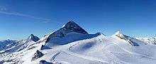
 The Olperer (right) and Schrammacher | |
| Highest point | |
| Elevation | 3,476 m (AA) (11,404 ft) |
| Prominence | 1,230 m (4,040 ft) |
| Isolation | 11.4 kilometres (7.1 mi) |
| Coordinates | 47°03′12″N 11°39′32″E / 47.05333°N 11.65889°ECoordinates: 47°03′12″N 11°39′32″E / 47.05333°N 11.65889°E |
| Geography | |
| Parent range | Zillertal Alps |
| Geology | |
| Mountain type | Rock summit |
| Type of rock | Granite, gneiss |
| Climbing | |
| First ascent | 1867 Paul Grohmann, Georg Samer and Jakob Huber over the southeast ridge (Südostgrat) |
| Easiest route | Olperer Hut, southeast ridge (with small Schneegupf firn field), or north ridge from Geraer Hut over sections of glacier |

The Olperer is a 3,476 metre high mountain in the Zillertal Alps in the Austrian federal state of Tyrol. It is the main summit on the Tux Crest (Tuxer Kamm) and is often crossed in the summer as climbers transit from the Olperer Hut to the Geraer Hut. It was first climbed on 10 September 1867 along the southeast ridge (Südostgrat) by Paul Grohmann, Georg Samer and Gainer Jackl.[1] On its north flank is the ski region known as Hintertux Glacier on the Gefrorene-Wand-Kees glacier (also called the Tuxer Ferner).
Location and area
The Olperer, with its pyramidal summit block, presents a striking appearance. As a result of that and because of its geographical prominence over its nearby peaks, the summit is a popular viewing point. It lies about four kilometres as the crow flies northwest of the Schlegeisspeicher dam and seven kilometres south of Hintertux. Its neighbours are, to the north and separated by the Wildlahnerscharte (3,220 m),the Großer Kaserer at 3,266 metres, to the southeast along the crest the 3,381 metre high Fußstein and, to the northeast, separated by the Großes Riepenkees glacier, lie the twin peaks of the Gefrorene-Wand-Spitzen, the southern summit of which lies at a height of 3,270 metres.
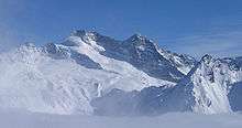 View from the northwest. Right: the Fußstein
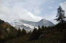 The Olperer and the Fußstein. View from Wildlahnertal near Schmirn
 South face of Olperer
Sources and maps
- H. Klier und W. Klier: Alpine Club Guide Zillertaler Alpen, Munich, 1996, ISBN 3-7633-1269-2
- Alpine Club Map 1:25,000, Sheet 35/1, Zillertaler Alpen West
References
- ↑ Zeitschrift des Deutschen und Oesterreichischen Alpenvereins, Vol. II, 1870/71, Munich, 1871, pp. 132 f.
External links
- The Olperer at Summitpost
- Bergrettung Ginzling – info about the Zillertal Alps
- Olperer Southeast and North Ridges: Tour description with photos at alpin-welt.at