Oleksandriia, Rivne Oblast
| Oleksandriia Олександрі́я | |||
|---|---|---|---|
| Village | |||
| |||
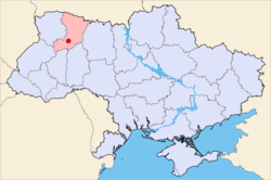 Location within the Rivne Oblast | |||
| Coordinates: 50°43′56″N 26°20′43″E / 50.73222°N 26.34528°ECoordinates: 50°43′56″N 26°20′43″E / 50.73222°N 26.34528°E | |||
| Country |
| ||
| Oblast | Rivne Oblast | ||
| Raion | Rivne Raion | ||
| Silska Rada | Novomalyn Silska Rada | ||
| Founded | 1569 | ||
| Area | |||
| • Total | 1.45 km2 (0.56 sq mi) | ||
| Elevation | 189 m (620 ft) | ||
| Population (2001) | |||
| • Total | 2,397 | ||
| • Density | 1,653.1/km2 (4,282/sq mi) | ||
| Time zone | UTC+2 (EET) | ||
| • Summer (DST) | UTC+3 (EEST) | ||
| Postal code (Index) | 35320 | ||
| Area code(s) | +380 362 | ||

Oleksandríja, also Aleksandria (Ukrainian: Олександрі́я), is a village in Rivne Raion, Rivne Oblast, Ukraine. As of 2001, the community had 2397 residents. Postal code — 35320.[1] KOATUU code — 5624680401.
History
The Germans occupied the city during War War II from 1941 - 1944. A witness recounted of the Germans' occupation: "When they arrived, the German soldiers burned the synagogue near the river and set fire to the Jewish houses. They were terrible. The Jews tried to take the furniture from their houses so it wouldn’t burn."[2]
References
- ↑ Registration card Archived 2012-03-11 at the Wayback Machine. on the website of the Verkhovna Rada of Ukraine (in Ukrainian)
- ↑ "Yahad Interactive Map". Execution Sites of Jewish Victims Investigated by Yahad-In Unum. Retrieved 20 January 2015.
External links
- Web-site of Oleksandriia (in Ukrainian)
- Aleksandria in the New York Public Library (in Hebrew)
- Weather in the Oleksandriia (in Ukrainian)
This article is issued from
Wikipedia.
The text is licensed under Creative Commons - Attribution - Sharealike.
Additional terms may apply for the media files.