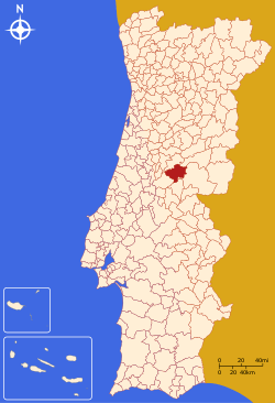
Oleiros, Portugal
| Oleiros | |||
|---|---|---|---|
| Municipality | |||
| |||
 | |||
| Coordinates: 39°55′07″N 7°54′46″W / 39.9186°N 7.9128°WCoordinates: 39°55′07″N 7°54′46″W / 39.9186°N 7.9128°W | |||
| Country |
| ||
| Region | Centro | ||
| Subregion | Pinhal Interior Sul | ||
| Intermunic. comm. | Beira Baixa | ||
| District | Castelo Branco | ||
| Parishes | 10 | ||
| Government | |||
| • President | José Santos Marques (PSD) | ||
| Area | |||
| • Total | 471.09 km2 (181.89 sq mi) | ||
| Population (2011) | |||
| • Total | 5,721 | ||
| • Density | 12/km2 (31/sq mi) | ||
| Time zone | WET/WEST (UTC+0/+1) | ||
| Website | http://www.cm-oleiros.pt/ | ||

Oleiros (Portuguese pronunciation: [oˈlɐjɾuʃ]) is a municipality in the district of Castelo Branco in Portugal. The population in 2011 was 5,721,[1] in an area of 471.09 km².[2] The present mayor is José Santos Marques, elected by the Social Democratic Party. The municipal holiday is the Monday after the 2nd Sunday of August.
Economy
Built in 2006, a wind farm (Pinhal Interior Wind Farm) operates in Oleiros, comprising a 54 MW power generation capacity.
Population
Oleiros has a total population of 5,271 in 2011.
ParishesAdministratively, the municipality is divided into 10 civil parishes (freguesias):[3]
References
External links
| |||||||||||||||||||||||||||||||||||||||||||||
This article is issued from
Wikipedia.
The text is licensed under Creative Commons - Attribution - Sharealike.
Additional terms may apply for the media files.