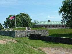
Old Fort Erie
| Fort Erie National Historic Site of Canada | |
|---|---|
 | |
| Location |
350 Lakeshore Road Fort Erie, Ontario, Canada L2A 1B1 |
| Coordinates | 42°53′35.70″N 78°55′25.74″W / 42.8932500°N 78.9238167°WCoordinates: 42°53′35.70″N 78°55′25.74″W / 42.8932500°N 78.9238167°W |
| Built |
1764 (original fort) 1805–1808 (present fort) |
| Original use | Military fort |
| Current use | Living museum |
| Governing body | Niagara Parks Commission |
 Location of Fort Erie National Historic Site of Canada in Southern Ontario | |
| Designated | 28 May 1933 |
Old Fort Erie, also known as Fort Erie, or the Fort Erie National Historic Site of Canada, was the first British fort to be constructed as part of a network developed after the Seven Years' War (often referred to as the French and Indian War in the United States) was concluded by the Treaty of Paris (1763) at which time all of New France had been ceded to Great Britain. It is located on the southern edge of the Town of Fort Erie, Ontario, directly across the Niagara River from Buffalo, New York.[1]
The fort and surrounding battlefield are owned and operated by the Niagara Parks Commission, a self-funded agency of the Ontario provincial government.
History
The British established control by occupying the French forts and by constructing a line of communications along the Niagara River and Upper Great Lakes. The original fort, built in 1764, was located on the Niagara River's edge below the present fort. It served as a supply depot and a port for ships transporting merchandise, troops and passengers via Lake Erie to the Upper Great Lakes.[1] In 1795, the fort consisted of some wooden blockhouses surrounded by a wooden palisade (dropped from the plan was a magazine, officer's quarters, storehouses and guard house). Provisions were stored inside the fort, and just outside was a large wooden magazine (original plans was to have it built inside the fort) as well as houses for workmen.[2] The fort was damaged by winter storms and in 1803, plans were made for a new fort on the higher ground behind the original. It was larger and made of flintstone but was not quite finished at the start of the War of 1812.[3][1]
The fort first saw action as a supply base for British troops, United Empire Loyalists Rangers and Iroquois Warriors during the American Revolution. The little fort at the water's edge suffered considerable damage due to continuous winter storms. In 1803, planning was authorized for a new Fort Erie on the heights behind the original post. The new fort was made more formidable being constructed of the Onondaga Flintstone that was readily available in the area.
War of 1812 (1812–1815)
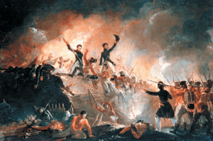
Fort Erie was the site of the bloodiest battlefield in the history of Canada. This new fort was unfinished when the United States declared war on June 18, 1812. Part of the garrison of Fort Erie fought at the Battle of Frenchman's Creek against an American attack in November 1812. In 1813, Fort Erie was held for a period by U.S. forces and then abandoned on June 9, 1813. The fort had been partially dismantled by the small garrison of British troops and Canadian Militia as they withdrew.
British reoccupation followed American withdrawal from the area in December 1813. The British attempted to rebuild the fort. On July 3, 1814 another American force landed nearby and again captured Fort Erie. The U.S. Army used the fort as a supply base and expanded its size. At the end of July, after the Battles of Chippewa and Lundy's Lane, the American army withdrew to Fort Erie and were besieged by the British. In the early hours of August 15, 1814, the British launched a four-pronged attack against the fortifications. A well-prepared American defence and an explosion in the North East Bastion destroyed the British chance for success with the loss of over 1,000 of their men.
An American sortie on September 17 captured two of the British batteries and the American troops were able to spike the guns in one of them before being driven back to the fort. Brevet Lieutenant Colonel Eleazer D. Wood was killed leading this sortie. Shortly afterward, the British lifted the siege and retired to positions to the north at Chippawa. After an unsuccessful American attack at Cook's Mills, west of Chippawa, news reached the American forces that the eastern seaboard of the U.S. was under attack. On November 5, 1814, with winter approaching, the Americans destroyed the fort and withdrew to Buffalo.[1]
Mid-19th century (1814–1866)
The Treaty of Ghent was signed December 24, 1814, ending the War of 1812. Fearing further American attacks, the British continued to occupy the ruined fort until 1823. Some of the stones from the fort were then incorporated into the construction of St. Paul's Anglican Church in 1824, which stands today (rebuilt after fire and explosion in 1892[4]) on the Niagara Parkway 3 km (1.9 mi) north of the fort.
The town of Fort Erie began to grow north of the fortifications when a rail terminus and station were constructed.
The Fenian Raids (1866)
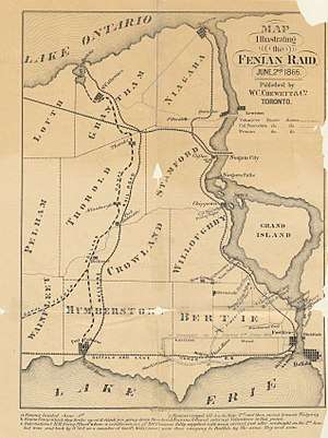
The Fenians, (Irish-American veterans of the American Civil War demanding independence from Britain for Ireland), mounted several raids on Upper Canada. One was quite large, at Fort Erie on 1 June 1866 after crossing the Niagara River with a thousand men, or 1500 men, depending on the source of the report.[5] The Fenians occupied the town and demanded food and horses. The only payment they were able to offer was Fenian bonds; these were not acceptable to the citizens. The Fenians then cut the telegraph wires and tore up some railway tracks. Afterwards, they marched to Chippewa and the next day to Ridgeway where they fought the Battle of Ridgeway, a series of skirmishes with the Canadian militia.[6]
The Fenians then returned to Fort Erie where they defeated a small force of the Canadian militia. Unable to get reinforcements from across the river which was guarded by the Americans, and worried about the large force of British and militia that was approaching, the Fenian commander decided to retreat to the U.S. Some of his troops deserted. Approximately 850 surrendered to forces of the American navy. This was the last notable Fenian raid on Upper Canada.[7][8]
Recent history (1866–present)
The fort laid vacant with old parts of the barracks, walls and mill still standing and eventually settled by military pensioners and other settlers until it was sold to the Niagara Parks Commission in 1901.[9]
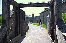
The reconstruction of the fort was started in 1937 (featuring only the walls and two barracks). The reconstruction was jointly sponsored by the Provincial and Federal governments and the Niagara Parks Commission. The fort was restored to the 1812-1814 period and officially reopened on July 1, 1939. During the restoration, a mass grave of 150 British and 3 American soldiers was uncovered and currently lies beneath a monument which was originally erected in the fort's ruins in 1904. The Parkway starts at Fort Erie and continues 56 km (35 mi) north to Lake Ontario. Sir Winston Churchill was quoted saying that the parkway was "the prettiest Sunday drive in the world." Each year, during the second weekend of August, hundreds of historical re-enactment enthusiasts come together to reenact the siege of Fort Erie.
On 28 June 1985 Canada Post issued 'Fort Erie, Ont.' one of the 20 stamps in the "Forts Across Canada Series" (1983 & 1985). The stamps are perforated 12½ x 13 and were printed by Ashton-Potter Limited based on the designs by Rolf P. Harder. [10]
Affiliations
The Museum is affiliated with: CMA, CHIN, and Virtual Museum of Canada.
See also
References
- 1 2 3 4 "Old Fort Erie History ". Niagara Parks, Canada. Archived from the original on 15 August 2010. Retrieved 6 December 2010.
- ↑ François-Alexandre-Frédéric duc de La Rochefoucauld-Liancourt (1800). Travels Through the United States of North America: The Country of the Iroquois, and Upper Canada, in the Years 1795, 1796, and 1797. R. Phillips. p. 382.
- ↑ "Archived copy". Archived from the original on 2017-04-28. Retrieved 2017-04-27.
- ↑ "St Paul's Anglican Church Fort Erie - Fort Erie, Ontario". JoinMyChurch.com. Retrieved 9 May 2018.
- ↑ https://www.archives.gov.on.ca/en/explore/online/fenians/civil_war_era.aspx#sthash.lvsl257t.dpuf
- ↑ "Archived copy". Archived from the original on 2005-08-30. Retrieved 2017-09-07.
- ↑ "The Fenian Raid 1866". 23 February 2012. Retrieved 9 May 2018.
- ↑ For the figure of 850, see: H.W. Hemans to Lord Monck, telegram June 3, 1866, in [s.n.] Correspondence Relating to the Fenian Invasion and Rebellion of the Southern States, Ottawa: 1869. p. 142; also Colonel Lowry, Report, June 4, 1866, Miscellaneous Records Relating to the Fenian Raids, British Military and Naval Records "C" Series, RG8-1, Volume 1672; Microfilm reel C-4300, p. 282. (Public Archives of Canada)
- ↑ "HistoricPlaces.ca - HistoricPlaces.ca". www.historicplaces.ca. Retrieved 9 May 2018.
- ↑ Canada Post issued 'Fort Erie, Ont.' Archived 2017-03-05 at the Wayback Machine.
Further reading
- Whitehorne, Joseph, W.A., While Washington Burned: The Battle for Fort Erie, 1814, 1992, reprint 2006, The Nautical and Aviation Publishing Company of America, Charleston, South Carolina.
- Historic Fort Erie brochure, The Niagara Parks Commission, 1991.
External links
| Wikimedia Commons has media related to Fort Erie. |
- Old Fort Erie - Niagara Parks
- Town of Fort Erie
- Images from the Historic Niagara Digital Collections at the Niagara Falls Public Library
- We Are Fort Erie
| Provinces | |
|---|---|
| Territories | |
| Other countries | |
| |