Old Dongola
| دنقلا العجوز | |
 Church of the Granite Columns in Old Dongola | |
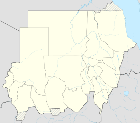 Shown within Sudan | |
| Location | Northern S, Sudan |
|---|---|
| Region | Nubia |
| Coordinates | 18°13′N 30°45′E / 18.217°N 30.750°ECoordinates: 18°13′N 30°45′E / 18.217°N 30.750°E |
| Type | Settlement |
| Site notes | |
| Condition | In ruins |
Old Dongola (Old Nubian: Tungul; Arabic: دنقلا العجوز, Dunqulā al-ʿAjūz) is a deserted town in what is now Northern State, Sudan, located on the east bank of the Nile opposite the Wadi Howar. An important city in medieval Nubia, and the departure point for caravans west to Darfur and Kordofan, from the fourth to the fourteenth century Old Dongola was the capital of the Makurian state. A Polish archaeological team has been excavating the town since 1964.
The urban center of the population moved downstream 80 km (50 miles) to the opposite side of the Nile during the nineteenth century, becoming the modern Dongola.
History
Foundation and heyday

Old Dongola was founded in the fifth century as a fortress, but a town soon evolved around it. Later with the arrival of Christianity it became the capital of Makuria, and several churches were built. These include, to use the names contemporary archeologists have given them, Building X and the Church with the Stone Pavement. These two structures were erected about 100 meters apart from the walled town centre, indicating that at this time the town already extended over the original walls of the fortress. Building X was soon replaced by the Old Church.

In the middle of the seventh century, the two main churches were destroyed, but rebuilt soon after. Building material was taken from the Old Church and used to repair the city walls. Archeologists believe this destruction is evidence of the First (642) and Second Battles of Dongola (652).
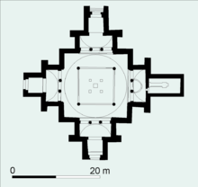
At the end of the seventh Century, the Church of the Granite Columns was erected over the Old Church. Adorned with 16 granite columns, each with richly decorated granite capitals, the Church of the Granite Columns perhaps was the cathedral of Old Dongola.
The heyday of Old Dongola was in the tenth century. The Church of the Stone Pavements was replaced with the Cruciform Church at this time. Other buildings in use in Old Dongola at this time include many other churches, at least two palaces, and a sizable monastery on its north side. Several houses were well equipped and had bath rooms and wall paintings.
_(34019327053).jpg)
The Book of Knowledge, a travelogue compiled by a Spanish monk soon after 1348, mentions that Genoese merchants had settled in Old Dongola; they may have penetrated there as a consequence of the commercial treaty of 1290 between Genoa and Egypt.[1]
The Throne Hall
The Throne Hall is a massive defence-like building of 28 m by 18 m by 12 m situated on a rocky spur to the east from the fortress. Built in the 8th century, this building contained the Throne Hall of the Makurian kings.[2] In 1317 it was turned into a mosque, an event which is preserved in a foundation stela erected by Sayf al-Din Abdullah Barshambu. The ceremonial Throne Hall on the first floor was turned into a prayer room. The mosque remained in use until 1969, when the building was converted in a historic monument.[3]
Decline
However, during the thirteenth and fourteenth centuries the town was in decline. It was attacked by Arabs several times. A surviving inscription erected in Old Dongola bears the date of 1317, is commonly understood to be the record of a military expedition sent by the Sultan of Egypt to place his nominee Abdullah, perhaps a Muslim Nubian, on the throne.[4]
.jpg)
Under the Funj, Old Dongola became the capital of the Northern provinces. The French traveller Charles-Jacques Poncet visited the city in 1699, and in his memoirs he described it as located on the slope of a sandy hill. His description of Old Dongola continues:
- The houses are ill built, and the streets half deserted and fill'd with heaps of sand, occasion'd by floods from the mountains. The castle is in the very center of the town. It is large and spacious, but the fortifications are inconsiderable. It keeps in awe the Arabians, who are masters of the open country.[5]
Islamic cemetery
A large Islamic cemetery with numerous qubbas, erected in the 17th century, testify to the importance of Old Dongola also in postmedieval times.
Notes
| Wikimedia Commons has media related to Old Dongola. |
- ↑ O.G.S. Crawford, "Some Medieval Theories about the Nile", Geographical Journal, 114 (1949), pp. 7f
- ↑ Artur Obłuski, Włodzimierz Godlewski, Wojciech Kołątaj, Stanisław Medeksza, Cristobal Calaforra-Rzepka; The Mosque Building in Dongola. Conservation and Revitalization project; Polish Archaeology in the Mediterranean 22 (Research 2010); 2013; pp.248–272; ISSN 1234–5415 (Print), ISSN 2083–537X (Online)
- ↑ M. Elfasi (editor); General History of Africa III. Africa from the Seventh to the Eleventh Century; 1988; pp.199-201; ISBN 92-3-101 709-8
- ↑ P. L. and M. Shinnie, "New Light on Medieval Nubia", Journal of African History, 6 (1965), p. 265
- ↑ Charles Jacques Poncet in The Red Sea and Adjacent Countries, William Foster, editor (London: Hakluyt Society, 1949), pp. 99f.