Okabe, Shizuoka
| Okabe 岡部町 | |||
|---|---|---|---|
| Former municipality | |||
| |||
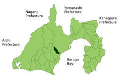 Location of Okabe in Shizuoka Prefecture | |||
 Okabe Location in Japan | |||
| Coordinates: 34°55′N 138°17′E / 34.917°N 138.283°ECoordinates: 34°55′N 138°17′E / 34.917°N 138.283°E | |||
| Country | Japan | ||
| Region | Chūbu (Tōkai) | ||
| Prefecture | Shizuoka Prefecture | ||
| District | Shida | ||
| Merged |
January 1, 2009 (now part of Fujieda, Shizuoka) | ||
| Area | |||
| • Total | 53.29 km2 (20.58 sq mi) | ||
| Population (December 31, 2008) | |||
| • Total | 12,210 | ||
| Symbols | |||
| • Tree | Osmanthus | ||
| • Flower | Prunus Mume | ||
| Time zone | UTC+9 (JST) | ||
| Website | City of Fujieda | ||


Okabe (岡部町 Okabe-chō) was a town located in Shida District, Shizuoka, Japan.
Okabe developed in the Edo period as Okabe-juku, a post town on the Tōkaidō.
As of 2003, the town had an estimated population of 12,839 and a density of 240.93 persons per km². The total area was 53.29 km². The town was served by an interchange on Japan National Route 1, but had no train service.
On January 1, 2009, Okabe was merged into the expanded city of Fujieda and thus no longer exists as an independent municipality. Shida District was dissolved as a result of the merger.[1]
References
- ↑ https://web.archive.org/web/20070728082506/http://www.kokudo.or.jp/new/cities/sub/chubu/22.htm. Archived from the original on July 28, 2007. Retrieved September 8, 2008. Missing or empty
|title=(help)
This article is issued from
Wikipedia.
The text is licensed under Creative Commons - Attribution - Sharealike.
Additional terms may apply for the media files.