Ohaeawai
| Ohaeawai | |
|---|---|
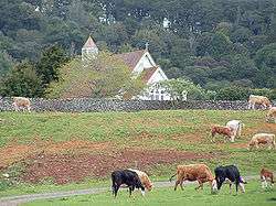 St Michael's Church sits atop the pa site today in a pastoral setting | |
 Ohaeawai | |
| Coordinates: 35°21′4″S 173°52′55″E / 35.35111°S 173.88194°E | |
| Country | New Zealand |
| Region | Northland Region |
| District | Far North District |
| Population (2006) | |
| • Total | 711 |
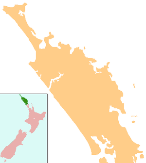
Ohaeawai is a small village at the junction of State Highway 1 and State Highway 12 in the Far North District of New Zealand, some 250 km (160 mi) from Auckland. The town of Kaikohe is 10.4 km (6.5 mi) to the west, and the Bay of Islands is a short drive to the east.
Nearby is the site of the bloody Battle of Ohaeawai fought at Pene Taui's pā (fort) during the Flagstaff War in 1845. The therapeutic mercurial waters of the minor health spa of Ngawha Springs are in a small thermal area to the west, where Northland prison is situated. The village is the centre of a rich farming district as a result of the fertile volcanic soils, with the district known to the Ngāpuhi as Tai-a-mai.[1]
Taiamai was the name given to a large boulder of volcanic rock situated about 400 m (quarter mile) south east of the Ohaeawai hotel. This prominent rock stands about 3.5 metres (11 ft) high, and was formerly an uruuru whenua, a place where travellers recited a charm and placed a small offering, such as a branch or tuft of grass, in order to placate the spirits of that place.[1]
In 1845 Te Ruki Kawiti and Pene Taui fortified Taui's pā (fort), which British forces laid siege to in July that year. The outcome of the Battle of Ohaeawai is considered to be a defeat of the British colonial forces. St. Michael's Anglican Church was built in 1870 on the site of the pā.[2]
St. Michael's Anglican Church is 7.2 km (4.5 mi) from Kaikohe and 3.2 km from the township of Ohaeawai, situated on a gentle rise a short distance west of the main road.[3] In August 2018 the battleground area around the church, including the urupa (cemetery), was added to the Heritage New Zealand list as a wāhi tapu, a place sacred to the Ngati Hine iwi and of historic significance.[4]
The locality is usually called Ngawha, from the hot springs in the neighbourhood. Cowan (1922) asserts that the site of the church (and earlier pā) is the true Ohaeawai and the European township which has appropriated the name should properly be known as Taiamai.[5]
The 2006 New Zealand census recorded Ohaeawai's population as 711, a decrease of 15 people since the 2001 census.[6]
Education
Ohaeawai School is a coeducational contributing primary (years 1-6) school with a decile rating of 2 and a roll of 119.[7]
Notes
- 1 2 Best, Elsdon (1927). "Old Forts of the Taiamai District, Bay of Islands". The Pa Maori. Whitcombe and Tombs Limited.
- ↑ "New Zealand - Has the Work Died Out?". The Church Missionary Gleaner. 20: 115. 1870. Retrieved 1 December 2013.
- ↑ "St. Michael's, Ngawha". Don Donovan.
- ↑ Jenny Ling (August 2018). "Bloody battle site tapu". Northern News. Retrieved 8 August 2018.
- ↑ Cowan, James (1922). "Volume I: 1845–1864". The New Zealand Wars: a history of the Maori campaigns and the pioneering period. Wellington: R.E. Owen. pp. 73–144.
- ↑ Quickstats about Ohaeawai
- ↑ "Te Kete Ipurangi - Ohaeawai School". Ministry of Education.
External links
Coordinates: 35°21′04″S 173°52′55″E / 35.35111°S 173.88194°E
| Authority control |
|---|