Oger, Marne
| Oger | ||
|---|---|---|
 | ||
| ||
 Oger Location within Grand Est region  Oger | ||
| Coordinates: 48°57′30″N 4°00′47″E / 48.9583°N 4.0131°ECoordinates: 48°57′30″N 4°00′47″E / 48.9583°N 4.0131°E | ||
| Country | France | |
| Region | Grand Est | |
| Department | Marne | |
| Arrondissement | Épernay | |
| Canton | Vertus-Plaine Champenoise | |
| Area1 | 15.06 km2 (5.81 sq mi) | |
| Population (1999)2 | 558 | |
| • Density | 37/km2 (96/sq mi) | |
| Time zone | UTC+1 (CET) | |
| • Summer (DST) | UTC+2 (CEST) | |
| INSEE/Postal code | 51411 /51190 | |
|
1 French Land Register data, which excludes lakes, ponds, glaciers > 1 km2 (0.386 sq mi or 247 acres) and river estuaries. 2 Population without double counting: residents of multiple communes (e.g., students and military personnel) only counted once. | ||

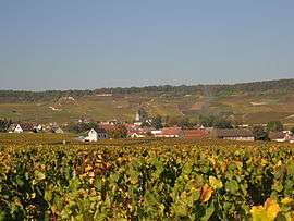
Oger is a former commune in the Marne department in north-eastern France. On 1 January 2018, it was merged into the new commune of Blancs-Coteaux.[1]
Champagne
The village's vineyards are located in the Côte de Blancs subregion of Champagne, and are classified as Grand Cru (100%) in the Champagne vineyard classification.
See also
References
- ↑ Arrêté préfectoral 21 December 2017 (in French)
| Wikimedia Commons has media related to Oger. |
This article is issued from
Wikipedia.
The text is licensed under Creative Commons - Attribution - Sharealike.
Additional terms may apply for the media files.