Office of the Prime Minister and Privy Council
| Office of the Prime Minister and Privy Council | |
|---|---|
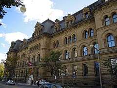 The building seen from Wellington Street in 2010 | |
| Former names |
Southwest Departmental Building, Langevin Block |
| General information | |
| Type | Office building |
| Architectural style | Second Empire |
| Address | 80 Wellington St |
| Town or city | Ottawa, Ontario |
| Country | Canada |
| Current tenants |
Office of the Prime Minister Privy Council Office |
| Construction started | 1884 |
| Completed | 1889 |
| Owner | The Queen in Right of Canada |
| Landlord | National Capital Commission |
| Design and construction | |
| Architect | Thomas Fuller |
| Designations | Classified Federal Heritage Building |
| Official name | Langevin Block National Historic Site of Canada |
| Part of | Confederation Square National Historic Site of Canada |
The Office of the Prime Minister and Privy Council (French: Bureau du Premier ministre et du Conseil privé) building, formerly known as the Langevin Block (French: Édifice Langevin, IPA: [lɑ̃ʒvɛ̃]), is an office building facing Parliament Hill in Ottawa, Ontario, Canada. As the home of the Privy Council Office and Office of the Prime Minister, it is the working headquarters of the executive branch of the Canadian government.
The term Langevin Block was previously used as a metonym for the Prime Minister's Office and the Privy Council Office. The building was named after Father of Confederation and cabinet minister Hector Langevin.[1] On June 21, 2017, Prime Minister Justin Trudeau renamed the building due to objections by Indigenous people of the name's use, due to Hector Langevin's role in establishing the residential school system, associated with the abuse of Indigenous children and attempts to forcibly assimilate them.[2]
The building is a National Historic Site of Canada.[3]
Overview
While the offices of senior Privy Council Office officials remain in the Langevin Block, its use is now largely limited to the Prime Minister's Office, in addition to his or her office in the Centre Block of the Parliament Buildings.
Started in 1884 and completed in 1889, the block was the first federal government office building constructed outside the Parliament Hill precinct. It is built of sandstone obtained from a New Brunswick quarry owned by Charles Elijah Fish. It occupies a prominent place on Ottawa's Wellington Street, adjacent to the National War Memorial, Chateau Laurier, Government Conference Centre, Rideau Canal, National Arts Centre, High Commission of the United Kingdom in Ottawa, and the Sparks Street Mall. Originally named the Southwest Departmental Building during construction, its name from completion until 2017 came from Sir Hector-Louis Langevin, the Public Works Minister in the Cabinet of Sir John A. Macdonald.
The structure is distinctive in Ottawa for its Second Empire Style design because most government buildings from the period were built in the Gothic Revival style. It was designed by the Chief Dominion Architect Thomas Fuller, who also designed the original Parliament Buildings. In 2000, it was named by the Royal Architectural Institute of Canada as one of the top 500 buildings produced in Canada during the last millennium.[4]
The building is connected by a bridge to an office building at 13 Metcalfe Street.
In 2017, the Assembly of First Nations called for the building to be renamed, due to Hector Langevin's role in the creation of Canada's controversial Indian residential schools system.[1] On June 21, 2017 the building was renamed the Office of the Prime Minister and Privy Council.
See also
References
- 1 2 "Bellegarde, MPs urge feds to change name of Langevin Block". The Globe and Mail, February 16, 2017.
- ↑ Kirkup, Kristy (21 June 2017). "Father of Confederation's name stripped from Prime Minister's Office building". ctvnews.ca.
- ↑ Langevin Block National Historic Site of Canada. Canadian Register of Historic Places. Retrieved August 18, 2011.
- ↑ Cook, Marcia (May 11, 2000). "Cultural consequence". Ottawa Citizen. Canwest. Archived from the original on May 30, 2010. Retrieved October 11, 2009.
- Exploring Ottawa: an architectural guide to the nation's capital. Harold Kalman and John Roaf. Toronto: University of Toronto Press, 1983.
- Ottawa: a guide to heritage structures City of Ottawa, Local Architectural Conservation Advisory Committee; managing editor, Lucy Corbin. 2001
External links
- The Langevin Block from Yesterday to Today
- Langevin Block Canada's Historic Places
Coordinates: 45°25′25.23″N 75°41′49.42″W / 45.4236750°N 75.6970611°W
| Parliament of Canada |  | |
|---|---|---|
| Centre Block | ||
| Monuments | ||
| Parliamentary Precinct | ||
| Provinces | |
|---|---|
| Territories | |
| Other countries | |
| |