Oakland City station
S3
Oakland City
| |||||||||||||||
|---|---|---|---|---|---|---|---|---|---|---|---|---|---|---|---|
| MARTA rapid transit station | |||||||||||||||
 | |||||||||||||||
| Location |
1400 Lee Street SW Atlanta, GA 30310 | ||||||||||||||
| Coordinates | 33°43′01″N 84°25′31″W / 33.716848°N 84.4252°WCoordinates: 33°43′01″N 84°25′31″W / 33.716848°N 84.4252°W | ||||||||||||||
| Line(s) | |||||||||||||||
| Platforms | 1 island platform | ||||||||||||||
| Tracks | 2 | ||||||||||||||
| Connections |
| ||||||||||||||
| Construction | |||||||||||||||
| Structure type | Embankment | ||||||||||||||
| Parking | 337 spaces; daily parking | ||||||||||||||
| Bicycle facilities | 8 spaces | ||||||||||||||
| Disabled access | Yes | ||||||||||||||
| Other information | |||||||||||||||
| Station code | S3 | ||||||||||||||
| History | |||||||||||||||
| Opened | December 15, 1984 | ||||||||||||||
| Traffic | |||||||||||||||
| Passengers (2013) |
4,432 (avg. weekday)[1] | ||||||||||||||
| Services | |||||||||||||||
| |||||||||||||||
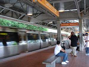
Oakland City is an embankment rail station in Atlanta, Georgia, serving the Red and Gold lines of the Metropolitan Atlanta Rapid Transit Authority (MARTA) rail system. Opened on December 15, 1984, it has one island platform between two tracks. Both sides of the station are accessed via a pedestrian underpass beneath adjacent roadways and, in the case of the east underpass, a freight railway. Though at-grade, the steep embankment on which this station is situated gives it the appearance of an elevated station. This station mainly serves the Oakland City, Sylvan Hills and Capitol View neighborhoods of Atlanta.
Bus service is provided at this station to Barge Road Park & Ride, South Fulton Medical Center, Sylvan Hills, and Greenbriar Mall.
Station layout
| P Platform level |
Southbound | ← Red Line, Gold Line toward Airport (Lakewood / Fort McPherson) |
| Island platform, doors will open on the left | ||
| Northbound | → Gold Line toward Doraville (West End) → → Red Line toward North Springs (West End) → | |
| G | Street Level | Entrance/Exit, fare barriers |
| L | Lower level | Passageway from street to platforms |
Bus routes
The station is served by the following MARTA bus routes:
- Route 79 - Sylvan Hills
- Route 83 - Campbellton Road / Greenbriar
- Route 162 - Myrtle Drive / Alison Court
- Route 172 - Sylvan Road / Virginia Avenue
References
- ↑ "2014 Transportation Fact Book" (PDF). Atlanta Regional Commission. Retrieved 9 January 2016.
External links