Nyamuragira
| Nyamuragira | |
|---|---|
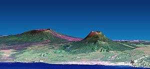 Nyamuragira (left) and Nyiragongo (right). Vertical scale exaggerated (1.5x). | |
| Highest point | |
| Elevation | 3,058 m (10,033 ft) [1] |
| Coordinates | 1°24′29″S 29°12′00″E / 1.408°S 29.2°ECoordinates: 1°24′29″S 29°12′00″E / 1.408°S 29.2°E [1] |
| Geography | |
 Nyamuragira Democratic Republic | |
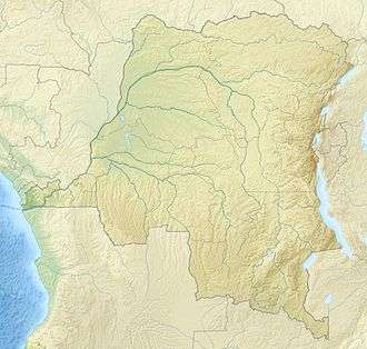
| Location | Nord-Kivu, Democratic Republic of the Congo |
| Parent range | Virunga Mountains |
| Geology | |
| Mountain type | Shield volcano |
| Last eruption | 2014 |
Nyamuragira, also known as Nyamulagira, is an active volcano in the Virunga Mountains of the Democratic Republic of the Congo, situated about 25 km north of Lake Kivu. The name is derived from the Kinyarwanda verb Kuragira inka, meaning to herd cows; Inka means cow or cows.
It has been described as Africa's most active volcano[2] and has erupted over 40 times since 1885.[3] As well as eruptions from the summit, there have been numerous eruptions from the flanks of the volcano, creating new smaller volcanoes that have lasted only for a short time (e.g. Murara from late 1976 to 1977).
Recent eruptions occurred on 2 January 2010 and 8 November 2011.
Geography and geology
Nyamuragira volcano is an active volcano near the city of Goma of the Democratic Republic of the Congo, situated about 25 km north of Lake Kivu. It is in the Nord-Kivu Province. It is 13 km north-north-west of Nyiragongo, the volcano which caused extensive damage to the city of Goma in its 2002 eruption. Nyamuragira has a volume of 500 cubic km, and covers an area of 1,500 km2. It has a low shield profile, and contrasts with adjacent steep-sided Nyiragongo volcano.
Sulfur dioxide
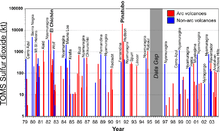
Nyamuragira volcano is responsible for a large portion of the sulfur dioxide released into the atmosphere by volcanoes.

2010 eruption
At dawn on 2 January 2010, Nyamuragira began spewing out lava flows. There are no settlements close to the volcano, but wildlife officials feared that the eruption may threaten the chimpanzees in the area. Another danger was that the lava could have flowed into the southern sector of Virunga National Park, where there are settlements and villages.[4]
Extensive lava flows from the 2010 eruption can be seen on satellite photographs[5] reaching 25 km south-west to Lake Kivu, about 22 km north-west and 35 km north-north-east.
2011 eruption
The volcano erupted again on November 5, 2011.[6]
That eruption produced a 400-meter high column of lava, and it is said to have been its largest eruption in 100 years.[7]
2013 activity
Goma volcanologists warn for an imminent eruption, as more steam and fumes are released from the volcano.
New lava lake formed in 2014
.jpg)
For the first time in 75 years, a new lava lake appeared at the volcano. That is one of the few volcanoes on Earth which have sustained lava lakes for several decades. The last formed lava lake at the volcano was emptied in the 1938 lava flow. The formation of the new lava lake occurred between June and August 2014 [8]. The lava lake has a depth of 500 metres. The lava lake is growing and can produce lava flows in the future. The eruption did not affect the communities in the area but left a lot of ash and air pollution. Sulfate aerosols formed by volcanic sulfur dioxide from the eruptions were observed as far as over the central Amazon rain forest in South America[9].
See also
References
- 1 2 "Nyamuragira". Global Volcanism Program. Smithsonian Institution. Retrieved 22 August 2006.
- ↑ Smets, B.; Wauthier, C.; d’Oreye, N. (2010), "A new map of the lava flow field of Nyamulagira (D.R. Congo) from satellite imagery", Journal of African Earth Sciences, 58 (5): 778–786, doi:10.1016/j.jafrearsci.2010.07.005
- ↑ "Volcano erupts in Congo". CNN. 2 January 2010. Retrieved 13 February 2011.
- ↑ "DR Congo Volcano Eruption Threatens Rare Chimpanzees". BBC News. 2 January 2010. Retrieved 2 January 2010.
- ↑ Google Earth Archived 8 September 2010 at the Wayback Machine. shows the crater and lava flows very clearly at coordinates -1.408333, 29.200000
- ↑ "Congo Volcano Erupts: Video". The Guardian. 8 November 2011. Retrieved 8 November 2011.
- ↑ "Nyamuragira Volcano, Democratic Republic of the Congo". Volcano Photos. Geographic.org. Retrieved 2011-12-26.
- ↑ "New Lava Lake Appears Atop African Volcano". iflscience. Retrieved 2017-11-15.
- ↑ Saturno, Jorge; et al. (2018), "African volcanic emissions influencing atmospheric aerosols over the Amazon rain forest", Atmospheric Chemistry and Physics, 18 (5): 10391–10405, doi:10.5194/acp-18-10391-2018
External links
- Nyamuragira Volcano
- Smithsonian Institution's Global Volcanism Program: Nyamuragira
- 2006 eruption
- "Congo volcano threat to villages" BBC report with video, 2010 eruption
- "Nyamuragira volcano - VolcanoDiscovery" Information, news, videos and photos from the 2011-2012 eruption