Nuttby Mountain
| Nuttby Mountain | |
|---|---|
| Highest point | |
| Elevation | 360 m (1,180 ft) |
| Coordinates | 45°33′17.42″N 63°13′26.71″W / 45.5548389°N 63.2240861°W |
| Geography | |
| Location | Colchester County, Nova Scotia |
| Parent range | Cobequid Mountains |
| Topo map | NTS O11/E11 |
| Climbing | |
| Easiest route | drive/hike |
Nuttby Mountain is a Canadian peak[1] in the Cobequid Mountains and at 360.6 metres is one of the highest elevation points on the mainland portion of Nova Scotia. Its longstanding claim to be the highest peak was disputed in 2017 when it was discovered that Higgins Mountain near Folly Lake is 363.7 metres and an unnamed peak near Hart Lake is 365.02 metres.[2]
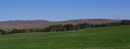
Located west of Route 311 in Colchester County some 20km north of Truro, the peak is accessible by vehicle using a gated road and is topped by telecommunication towers. A fire lookout tower stood there from 1937 to 2013.[3] A 45-megawatt wind farm was constructed on a 400-acre site on the mountain in 2010.[4] As of 2017 Nova Scotia Power owned 22 Enercon E82 turbines on the site with a total capacity of 50.6 MW.[5]
See also
- List of highest points of Canadian provinces and territories
- Nuttby, Nova Scotia, nearby settlement
References
- ↑ "Nuttby Mountain". Geographical Names Board of Canada. Natural Resources Canada. Retrieved 11 July 2017.
- ↑ Riley, Jonathan (January 25, 2017). "Move over Nuttby – Wentworth has mainland's highest point". Truro Daily News. Transcontinental Media. Retrieved 8 July 2017.
- ↑ Carter, Lyle (January 27, 2014). "Memories of the Nuttby fire tower". Truro Daily News. Transcontinental Media. Retrieved 8 July 2017.
- ↑ "Nuttby Mountain wind turbines arrive". CBC News. Canadian Broadcasting Corporation. Jul 16, 2010. Retrieved 12 July 2015.
- ↑ "Wind Farm Directory". Nova Scotia Power. Retrieved 11 July 2017.