Nowra Bridge
| Nowra Bridge | |
|---|---|
 Nowra Bridge | |
| Coordinates | 34°51′51″S 150°36′07″E / 34.86417°S 150.60194°ECoordinates: 34°51′51″S 150°36′07″E / 34.86417°S 150.60194°E |
| Carries | Automobiles |
| Crosses | Shoalhaven River |
| Locale | Nowra, New South Wales |
| Heritage status | |
| Characteristics | |
| Design | Truss bridge |
| Material | Steel |
| Total length | 342 metres (1,122 ft) |
| History | |
| Designer | C Shaler Smith |
| Construction end | 1881 |
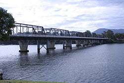
The Nowra Bridge joins the main area of Nowra to North Nowra and Bomaderry. It carries the Princes Highway over the Shoalhaven River and was originally intended to carry a double railway track, as part of the proposed extension of the South Coast line to Jervis Bay and possibly Eden. However, the railway was never extended past Bomaderry station where trains still terminate today, so the bridge was converted for road traffic, as the residents of Nowra wanted a road bridge that connected Bomaderry to Nowra. The bridge was designed by American engineer C Shaler Smith and is considered to be of historical significance.[1] It is shadowed by a newer, concrete bridge built to support increased traffic flows in the area.
The bridge was completed in 1881 and is built from wrought iron with a steel approach span. The bridge had a timber deck for 100 years until in 1981 reinforced concrete was laid over steel Armco decking. The pairs of cast iron piers are original and were supplied locally by the Atlas Foundry, Sydney. It was the largest bridge project in New South Wales prior to the 1889 Hawkesbury River Railway Bridge. Its full length is 342 metres (1,122 ft).[1]
References
- 1 2 "Nowra Bridge over the Shoalhaven River", Roads and Traffic Authority, 30 March 2004. Retrieved on 2008-11-20
External links
- NSW State Heritage Register - Nowra Bridge
- Nowra Bridge (Trove)
- Bridge into Nowra over the Shoalhaven River NLA Digital Collections
- Nowra - Second Bridge Construction by Sandown (Flickr)