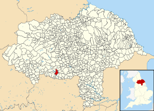
Norwood, North Yorkshire
| Norwood | |
|---|---|
| Civil parish | |
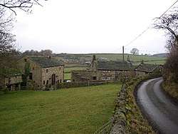 Some houses near a country lane in Norwood | |
 | |
| Coordinates: 53°58′12″N 1°40′34″W / 53.970°N 1.676°WCoordinates: 53°58′12″N 1°40′34″W / 53.970°N 1.676°W | |
| Country | England |
| Primary council | Harrogate |
| County | North Yorkshire |
| Region | Yorkshire and the Humber |
| Status | Parish |
| Government | |
| • Type | Parish Council |
| • EU Parliament | Yorkshire and the Humber |
| Population (2011 census[1]) | |
| • Total | 216 |
Norwood is a civil parish in the Harrogate district of North Yorkshire, England. According to the 2001 UK census, Norwood parish had a population of 200,[2] increasing to 216 at the 2011 Census. The parish lies on the eastern side of the Washburn Valley, and includes the eastern side of Swinsty Reservoir.
There is no village in the parish. The population is spread among a number of hamlets and scattered farms, including Norwood Bottom and Bland Hill. Norwood Hall is a 17th-century Grade II listed building.[3] Dob Park Bridge is a packhorse bridge, probably of 17th century origin, over the River Washburn.[4]
Norwood is pronounced locally as "Norood", just as Warwick is pronounced "Warrick".
Until 1950 the parish was known as Clifton with Norwood. It was historically a township in the parish of Fewston, and became a separate civil parish in 1866.[5]
References
- ↑ "Parish population 2011". Retrieved 6 August 2015.
- ↑ "2001 Census: Key Statistics: Parish Headcounts: Area: CP Norwood (Parish)". Neighbourhood Statistics. Office for National Statistics. Retrieved 5 October 2009.
- ↑ Historic England. "Details from image database (331478)". Images of England. Retrieved 15 March 2014.
- ↑ Historic England. "Details from image database (331475)". Images of England. Retrieved 15 March 2014.
- ↑ Vision of Britain website
External links
![]()