Norwegian County Road 828
| County Road 828 | |
|---|---|
|
Bokmål: Fylkesvei 828 Nynorsk: Fylkesveg 828 | |
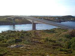 Åkviksundet Bridge viewed from Dønna | |
| Route information | |
| Length | 33.6 km (20.9 mi) |
| Major junctions | |
| North end | 809 Bjørn |
|
165 at Sør-Staulen 166 at Hestøya 162 at Herøy School (Sentralskolen) 161 at Kjerkåsen | |
| South end | Flostad |
| Location | |
| Counties | Nordland |
| Highway system | |
| County Roads in Norway | |
County Road 828 (Norwegian: Fylkesvei 828) is a 33.6-kilometer (20.9 mi) road in Nordland County, Norway.[1][2] It is also locally named Hæstadveien (Hæstad Road), Seløyveien (Seløy Road), Brunsvikveien (Brunsvik Road), Nord-Herøyveien (North Herøy Road), Sør-Herøyveien (South Herøy Road), Fagervikveien (Fagervik Road), and Flostadveien (Flostad Road).[3][4][5]
The road runs from the ferry terminal at Bjørn in the municipality of Dønna along the south coast of the island of Dønna, and then crosses the Åkviksundet Bridge and passes over several islands, including Staulen, Skardsøya, Kjeøya, and Hestøya, before reaching the island of Nord-Herøy in the municipality of Herøy. There one branch of the road runs northeast to the ferry terminal at Engan. The other branch runs southwest along the length of Nord-Herøy, crosses Herøysundet (Herøy Strait) via the Herøysund Bridge to the island of Sør-Herøy, turns south at Herøy School (Sentralskolen), and then turns east at Kjerkåsen before terminating at the ferry terminal at Flostad.
References
- ↑ Vegliste 2016: Fylkes- og kommunale veger. Nordland (PDF). Bodø: Statens vegvesen Region nord. p. 2.
- ↑ Thorsnæs, Geir (April 7, 2016). "Herøy – Nordland". Store norske leksikon. Retrieved October 21, 2017.
- ↑ "Verholmvalen". Norgeskart. Retrieved October 21, 2017.
- ↑ "Nord Herøy". Norgeskart. Retrieved October 21, 2017.
- ↑ "Aspmyro". Norgeskart. Retrieved October 21, 2017.