Norwegian County Road 13
| County Road 13 | |
|---|---|
|
Bokmål: Fylkesvei 13 Nynorsk: Fylkesveg 13 | |
  Location in Sogn og Fjordane county | |
| Route information | |
| Length | 80 km (50 mi) |
| Major junctions | |
| North end | E395 at Moskog |
| 610 at Eldalsosen | |
| South end | 1355 at Dragsvik |
| Location | |
| Counties | Sogn og Fjordane |
| Major cities | Balestrand, Holsen, Moskog |
| Highway system | |
| County Roads in Norway | |
County Road 13 (Norwegian: Fylkesvei 13) runs between the village of Dragsvik in Balestrand municipality and the village of Moskog in Førde municipality in Sogn og Fjordane county, Norway. Until 2010 the 80-kilometre (50 mi) long road was part of National Road 13 but administrative reforms passed this part of the road to the county. County Road 13 and a short section of County Road 55 are designated as one of eighteen National Tourist Routes in Norway. The road crosses the Gaularfjellet mountains.[1][2]
Route
Førde municipality
- E39 5 Moskog

- 483 to Haukedalen
Gaular municipality

- 421 at the village of Vik
- 610 to Hestad

Balestrand municipality
- Nystølen

- 152 to Menes


Media gallery
 Gaularfjell
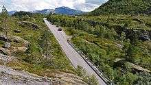 Rørvikfjellet
References
| Wikimedia Commons has media related to Fylkesveg 13. |
- ↑ "Nasjonal turistveg Gaularfjellet" (in Norwegian). Norwegian Public Roads Administration. Archived from the original on 5 October 2011. Retrieved 5 October 2011.
- ↑ "Gaularfjellet". Norwegian Public Roads Administration. Archived from the original on 5 October 2011. Retrieved 5 October 2011.
|  | |
This article is issued from
Wikipedia.
The text is licensed under Creative Commons - Attribution - Sharealike.
Additional terms may apply for the media files.