Finland–Norway border
| Wikimedia Commons has media related to Finland-Norway border. |
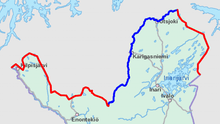
The border between Norway and Finland is 736 kilometers (457 mi) long.[1] It is a land and river border between two tripoints. The western tripoint is marked by Treriksröset, a stone cairn where both countries border Sweden. The eastern tripoint is marked by Treriksrøysa, a stone cairn where both countries border Russia. [2]
The border was defined in a treaty from 1751, but is then a part of the Border between the Kingdom of Sweden, ruling Finland, and the Crown of Denmark, ruling Norway. In the period 1738-1751 there were field investigations and negotiations on the border, although the Finnish part needed less negotiation. Cairns were erected after that with the last one at Nesseby in 1766. After Finland became a Grand Duchy of Russia, and the independent Kingdom of Norway was evoked into but in personal union with Sweden under the Swedish King, a treaty was again negotiated in 1816 with Russia. Defining the easternmost part of the borderzone. Between 1920-1944, the Petsamo area belonged to Finland, so the Finland–Norway border extended along the present Norway–Russia border to the ocean. The 1751 treaty also granted the Sami people the right to cross the border freely including their reindeer, as they always had done. In 1852, the border Norway–Finland/Russia was closed, causing trouble for the Sami, who needed the Finnish forests for reindeer winter grazing.
The Finland–Norway border is open as both countries are part of the Schengen Area. It is legal to cross the border anywhere if no customs declaration or passport check is needed. There is an 8-meter (26 ft) wide clear-cut zone along the land border. Almost half of the border follows the rivers Anarjohka and Tana.
List of road border crossings
From east to west:[3]
- Neiden (road 92), N
- Polmak (road 970/895), N
- Utsjoki (road E75), F
- Karigasniemi (road 92), F
- Kivilompolo (road E45), F
- Helligskogen (road E8), N
- N = customs station on the Norwegian side
- F = customs station on the Finnish side
All road crossings on this border have customs stations.
See also
References
- ↑ "Speech by President of the Republic of Finland Sauli Niinistö at the Norwegian Institute of International Affairs, 11th October 2012". President of Finland. 11 October 2012. Retrieved 29 May 2013.
- ↑ Svein Askheim. "Treriksrøysa – Sør-Varanger". Store norske leksikon. Retrieved October 1, 2016.
- ↑ Alphabetical list of customs offices