North Tower (lighthouse)
 North Tower, Schiermonnikoog | |
 Netherlands | |
| Location |
Schiermonnikoog Netherlands |
|---|---|
| Coordinates | 53°29′13.0″N 6°8′47.5″E / 53.486944°N 6.146528°ECoordinates: 53°29′13.0″N 6°8′47.5″E / 53.486944°N 6.146528°E |
| Year first constructed | 1854 |
| Construction | brick, dimension stone |
| Tower shape | tapered cylindrical tower with balcony and lantern |
| Markings / pattern | red tower and dome, white lantern |
| Height | 36 metres (118 ft) |
| Focal height | 44 metres (144 ft) |
| Intensity | 2,500,000 cd |
| Range | 28 nautical miles (52 km) |
| Characteristic | Fl (4) W 20s. |
| Admiralty number | B0938 |
| NGA number | 10008 |
| ARLHS number | NET-021 |
| Netherlands number | NL-2192[1] |
| Heritage |
Rijksmonument |
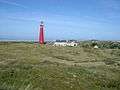
The North Tower is the unofficial name for one of the lighthouses on the Dutch island Schiermonnikoog, one of the Frisian Islands, on the edge of the North Sea; the other is the South Tower. It was built by H.G. Jansen & A. van Rhyn, and was activated in 1854. From the tower, weather reports are issued for the coastal waters. In 1998 it was painted red.
See also
Gallery

References
- ↑ Rowlett, Russ. "Lighthouses of Northern Netherlands". The Lighthouse Directory. University of North Carolina at Chapel Hill. Retrieved February 21, 2016.
External links
| Wikimedia Commons has media related to Lighthouse of Schiermonnikoog. |
This article is issued from
Wikipedia.
The text is licensed under Creative Commons - Attribution - Sharealike.
Additional terms may apply for the media files.