North Hartland, Vermont
| North Hartland, Vermont | |
|---|---|
| Census-designated place | |
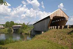 Willard Covered Bridge | |
 Location in Windsor County and the state of Vermont. | |
| Coordinates: 43°35′32″N 72°21′8″W / 43.59222°N 72.35222°WCoordinates: 43°35′32″N 72°21′8″W / 43.59222°N 72.35222°W | |
| Country | United States |
| State | Vermont |
| County | Windsor |
| Area | |
| • Total | 1.0 sq mi (2.7 km2) |
| • Land | 1.0 sq mi (2.6 km2) |
| • Water | 0.04 sq mi (0.1 km2) |
| Elevation | 370 ft (110 m) |
| Population (2010) | |
| • Total | 302 |
| • Density | 290/sq mi (110/km2) |
| Time zone | UTC-5 (Eastern (EST)) |
| • Summer (DST) | UTC-4 (EDT) |
| ZIP code | 05052 |
| Area code(s) | 802 |
| FIPS code | 50-50500[1] |
| GNIS feature ID | 1458736[2] |
North Hartland is a census-designated place (CDP) in the town of Hartland, Windsor County, Vermont, United States. As of the 2010 census, the population of the CDP was 302.[3]
Geography
North Hartland is located in eastern Windsor County at the junction of the Ottauquechee River with the Connecticut River. U.S. Route 5 passes through the village, connecting White River Junction to the north with Hartland and Windsor to the south. Interstate 91 passes just north of the village but provides no access to it.
References
- ↑ "American FactFinder". United States Census Bureau. Retrieved 2008-01-31.
- ↑ "US Board on Geographic Names". United States Geological Survey. 2007-10-25. Retrieved 2008-01-31.
- ↑ "Profile of General Population and Housing Characteristics: 2010 Demographic Profile Data (DP-1): North Hartland CDP, Vermont". U.S. Census Bureau, American Factfinder. Retrieved August 1, 2012.
Municipalities and communities of Windsor County, Vermont, United States | ||
|---|---|---|
| Towns | 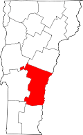 | |
| Villages | ||
| CDPs | ||
| Other communities | ||
This article is issued from
Wikipedia.
The text is licensed under Creative Commons - Attribution - Sharealike.
Additional terms may apply for the media files.