North Hamgyong Province
| North Hamgyong Province 함경북도 | |
|---|---|
| Province | |
| Korean transcription(s) | |
| • Chosŏn'gŭl | 함경북도 |
| • Hancha | 咸鏡北道 |
| • McCune‑Reischauer | Hamgyŏngbuk-to |
| • Revised Romanization | Hamgyeongbuk-do |
 | |
| Country | North Korea |
| Region | Kwanbuk |
| Capital | Chongjin |
| Subdivisions | 4 cities; 12 counties |
| Area | |
| • Total | 20,345 km2 (7,855 sq mi) |
| Population (2008)[1] | |
| • Total | 2,327,362 |
| • Density | 110/km2 (300/sq mi) |
| Dialect | Hamgyong |
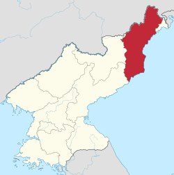
North Hamgyong Province (Hamgyŏngbukdo Korean pronunciation: [ham.ɡjʌŋ.buk̚.t͈o]) is the northernmost province of North Korea. The province was formed in 1896 from the northern half of the former Hamgyong Province.
Geography
The province is bordered by China on the north, South Hamgyong on the southwest, and Ryanggang on the west. On the east is the East Sea (Sea of Japan). The province is home to the Musudan-ri rocket launching site, and the Hoeryong concentration camp. In 2004 Rason was reabsorbed back into the province, and since 2010 Rason is again a Directly Governed City.
Most North Korean defectors that settle in South Korea come from North Hamgyong. Because of this, the province and its people are among the most well-researched topics of North Korea. Knowledge concerning the province is often erroneously generalized to concern the whole country, or ignored for being about "a backward province of a backward country ... unlikely to become popular reading: North Hamgyong is, after all, not only a very grim, but also a very boring place."[2]
Administrative divisions
North Hamgyong is divided into three cities (si) and 12 counties (kun).[3] These are further divided into villages (ri) in rural areas and dong (neighborhoods) in cities. Some cities are also divided into wards known as "kuyŏk", which are administered just below the city level.
Cities
Counties
|
|
|
|
See also
References
- ↑ http://unstats.un.org/unsd/demographic/sources/census/2010_PHC/North_Korea/Final%20national%20census%20report.pdf
- ↑ Tertitskiy, Fyodor (8 July 2016). "The flaws and biases in North Korean studies". NK News. Retrieved 27 July 2016.
- ↑ http://www.cybernk.net/infoText/InfoAdminstList.aspx?mc=AD0101&ac=A09
Places adjacent to North Hamgyong Province | ||||||||||
|---|---|---|---|---|---|---|---|---|---|---|
| ||||||||||
| Regions | |
|---|---|
| Provinces | |
| Direct-administered city | |
| Special cities | |
| Special administrative regions | |