North End, Croydon


North End is a pedestrianised road in Central Croydon, which includes entrances to the town's two main shopping centres, Centrale and the Whitgift Centre. The road has high street chains including Next, Zara, French Connection, Pret a Manger and large branches of department stores Debenhams and House of Fraser. North End was closed off to all forms of motor traffic in 1989, to entice shoppers to choose Croydon over its main south-east London rival Bromley.
On 26 November 2013, the Croydon Council approved a redevelopment of the town centre by The Croydon Partnership, [1] a joint venture by The Westfield Corporation and Hammerson[2] which would see the Whitgift Centre replaced with a Westfield shopping centre. London Mayor Boris Johnson approved the plan the following day. [3] The Croydon Advertiser listed the approval as an 'Historic Night for Croydon.' [4]
North End was the home of the last remaining Allders after the company went into liquidation, which led to the collapse of the group and the closure of the Croydon flagship store (opened in 1862). This Allders was the fourth largest department store in Britain and boasted the largest carpet department in Europe.
Transport links
North End has transport links both to the borough and to the surrounding areas in and out of London.
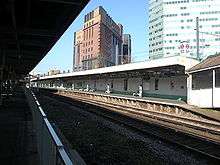
West Croydon railway station is located at the northern end of North End and is served by Southern and London Overground services. The East London Line was extended to West Croydon as its new terminus; now forming part of the London Overground project that connects Croydon with Crystal Palace and New Cross to Highbury & Islington across the River Thames and Clapham Junction. From these places connections are made to places like Watford, Euston, Barking, Stratford and Richmond. There is also a large bus station with many bus routes terminating there.[5]
East Croydon railway station is the second busiest railway station in Greater London outside of Travelcard Zone 1. It is located about 5 minutes east of the shopping area. There are services to London Victoria and London Bridge in Central London, Horsham, Gatwick Airport, Redhill, Caterham, Brighton and Tunbridge Wells. The rail services are provided by Southern and Thameslink.[6]
Tramlink also provides frequent services from the four nearby stops. Croydon Central railway station was a former station at what is now the Croydon Clocktower. It was built so that shoppers could get closer to the main district but the idea failed and it was all paved over.
Car parks around the centre include Centrale and Whitgift's own multi-storey car parks.
References
- ↑ Croydon Partnership | Home
- ↑ "Croydon £1bn shopping centre plan approved". BBC News. BBC.
Croydon £1bn shopping centre plan approved
- ↑ Davies, Gareth. "Boris Johnson approves Croydon's £1bn Whitgift redevelopment". Gareth Davies. Croydon Advertiser. Archived from the original on 23 September 2015.
Boris Johnson approves Croydon's £1bn Whitgift redevelopment
- ↑ Davies, Gareth. "Council gives green light to Westfield/Hammerson plan". Gareth Davies. Croydon Advertiser. Archived from the original on 23 September 2015.
Council gives green light to Westfield/Hammerson plan
- ↑ West Croydon National Rail
- ↑ East Croydon National Rail
See also
External links
![]()
