North Clarendon, Vermont
| North Clarendon, Vermont | |
|---|---|
| Village | |
 North Clarendon | |
| Coordinates: 43°34′00″N 72°57′55″W / 43.56667°N 72.96528°WCoordinates: 43°34′00″N 72°57′55″W / 43.56667°N 72.96528°W | |
| Country | United States |
| State | Vermont |
| County | Rutland |
| Elevation | 591 ft (180 m) |
| Time zone | UTC-5 (Eastern (EST)) |
| • Summer (DST) | UTC-4 (EDT) |
| ZIP code | 05759 |
| Area code(s) | 802 |
| GNIS feature ID | 1458721[1] |
North Clarendon is an unincorporated village in the town of Clarendon, Rutland County, Vermont, United States. The community is located along U.S. Route 7 and the Cold River, 3 miles (4.8 km) south of Rutland. North Clarendon has a post office with ZIP code 05759.[2][3]
References
- ↑ "North Clarendon". Geographic Names Information System. United States Geological Survey.
- ↑ United States Postal Service. "USPS - Look Up a ZIP Code". Retrieved May 22, 2017.
- ↑ "Postmaster Finder - Post Offices by ZIP Code". United States Postal Service. Retrieved May 22, 2017.
Municipalities and communities of Rutland County, Vermont, United States | ||
|---|---|---|
| City | 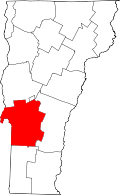 | |
| Towns | ||
| Village | ||
| CDPs | ||
| Other communities | ||
This article is issued from
Wikipedia.
The text is licensed under Creative Commons - Attribution - Sharealike.
Additional terms may apply for the media files.