North Carolina Highway 108
| ||||
|---|---|---|---|---|
 | ||||
| Route information | ||||
| Maintained by NCDOT | ||||
| Length | 22.1 mi[1] (35.6 km) | |||
| Major junctions | ||||
| West end |
| |||
|
| ||||
| East end |
| |||
| Location | ||||
| Counties | Polk, Rutherford | |||
| Highway system | ||||
| ||||

North Carolina Highway 108 (NC 108) is a 22-mile-long (35 km) two lane highway in North Carolina. It connects U.S. Route 176 (US 176) in Tryon to Rutherfordton and passes through both Polk County and Rutherford County. It is a rural country road through eastern Polk County and western Rutherford County, and moderately developed from Tryon through Columbus and in Rutherfordton. It is also known as Lynn Road between Tryon and Columbus, Mills Street through Columbus, and Tryon Road in Rutherford County.
Route description
NC 108 begins at US 176 in Tryon and travels east through the unincorporated town of Lynn, where it crosses the Pacolet River. NC 108 has an interchange with Interstate 26 (I-26) and US 74 in Columbus, and another interchange with US 74 east of Columbus. NC 108 passes through the center of Columbus, the county seat of Polk County, which is the most developed portion of the route in Polk County. Three miles (4.8 km) east of the second US 74 interchange, NC 108 intersects NC 9 at the unincorporated town of Mill Spring. The section from Tryon to Mill Spring closely follows the front range of the Blue Ridge Mountains. It passes over the Green River in Polk County and the Broad River in Rutherford County. NC 108 ends at the intersection of South Main Street (carrying US 221 and US 74 Business west) and Charlotte Road (carrying US 74 Business east and US 221A) in Rutherfordton.[1]
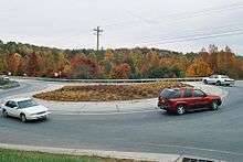
NC 108 has two roundabouts at the I-26/US 74 interchange. These were constructed between 2004 and 2007 to improve the level of service at the interchange.[2]
Future
Widening of NC 108 to four lanes with a median and limited turn lanes near I-26 in Columbus is included as part of North Carolina Department of Transportation (NCDOT) State Transportation Improvement Program (STIP) project I-4729. This project includes making the I-26/US 74 interchange a full interchange with access ramps from I-26 westbound to US 74 eastbound and US 74 westbound to I-26 eastbound. Currently, the partial interchange between the two freeways requires traffic to use NC 108 for access from I-26 west to US 74 east and US 74 west to I-26 east. The construction of the roundabouts was meant as a temporary fix to alleviate congestion at the interchange until funding for I-4729 became available.[2] The project has since been separated into two projects: I-4729A and I-4729B. I-4729A will reconfigure the interchange,[3] while I-4729B will widen NC 108. Construction of I-4729A is scheduled to begin in September 2017.[4] The project has been expedited due to the 2018 FEI World Equestrian Games being held at the nearby Tryon International Equestrian Center.[4]
The Comprehensive Transportation Plan Study Report for Polk County, completed in October 2008 by the Transportation Planning Branch of the NCDOT, recommends upgrading NC 108 in the future to a four-lane, divided facility from its western terminus at US 176 in Tryon to the US 74 interchange east of Columbus.[5] A new project to widen NC 108 from I-26 to Tryon - R-5838 - has been added to the draft 2018-2027 STIP.[6]
Major junctions
| County | Location | mi[1] | km | Destinations | Notes |
|---|---|---|---|---|---|
| Polk | Tryon | 0.0 | 0.0 | ||
| Columbus | 3.4– 3.6 | 5.5– 5.8 | Exit 67 (I-26) | ||
| | 5.1– 5.3 | 8.2– 8.5 | Exit 163 (US 74) | ||
| Mill Spring | 8.4 | 13.5 | |||
| Rutherford | Rutherfordton | 22.1 | 35.6 | Northern terminus of US 221A | |
| 1.000 mi = 1.609 km; 1.000 km = 0.621 mi | |||||
References
- 1 2 3 Google (February 28, 2016). "North Carolina Highway 108" (Map). Google Maps. Google. Retrieved February 28, 2016.
- 1 2 https://connect.ncdot.gov/projects/planning/FeasibilityStudiesDocuments/I-4729_Feasibility-Study_0314A_Report_2006.pdf
- ↑ https://www.ncdot.gov/download/projects/publichearings/I-4729A_Hearing_Map.pdf
- 1 2 https://www.ncdot.gov/download/projects/publichearings/I-4729A_Meeting_Handout_20170425.pdf
- ↑ Comprehensive Transportation Plan Study Report for Polk County - NCDOT Transportation Improvement Branch
- ↑ https://connect.ncdot.gov/projects/planning/STIPDocuments1/Draft%202017-2027%20STIP%20Division%2014.pdf
External links
