North Carolina's congressional districts
- Note: Several of these districts have had their boundaries changed in 2016 due to a Federal Court ruling on racial gerrymandering resulting in redistricting by the state legislature. The court ordered map shown below is the current one as of May 22, 2017 and moving forward.

North Carolina is currently divided into 13 congressional districts, each represented by a member of the United States House of Representatives. After the 2000 Census, the number of North Carolina's seats was increased from 12 to 13 due to the state's increase in population.
Constitutionality of the 2010 redistricting
On February 5, 2016, a three-judge panel of U.S. Court of Appeals for the Fourth Circuit and U.S. District Court for the Middle District of North Carolina judges ruled that the 1st and 12th districts' boundaries were unconstitutional and required new maps to be drawn by the legislature to be used for the 2016 election.[3] On May 22, 2017, the U.S. Supreme Court, in Cooper v. Harris, agreed that the 1st and 12th congressional district boundaries were unlawful racial gerrymanders, the latest in a series of cases dating back to 1993 by different parties challenging various configurations of those districts since their first creation.[4][5]
On January 9, 2018 a federal court stuck down North Carolina's congressional map, declaring it unconstitutionally gerrymandered to favor Republican candidates. The court ordered that the North Carolina General Assembly must redraw the district maps prior to the 2018 Congressional Elections.[6] On January 18, 2018, the United States Supreme Court stayed the federal court order pending review by the Court.[7]
Current districts and representatives
List of members of the North Carolinian United States House delegation, their terms, their district boundaries, and the districts' political rating according to the CPVI. The delegation has a total of 13 members, with 10 Republicans, and 3 Democrats.
| District | Representative | Party | CPVI | Incumbency | District map | |
|---|---|---|---|---|---|---|
| 1st |  G. K. Butterfield |
D | D+17 | July 20, 2004 – present | .tif.png) | |
| 2nd |  George Holding |
R | R+7 | January 3, 2013 – present | .tif.png) | |
| 3rd |  Walter Jones Jr. |
R | R+12 | January 3, 1995 – present | .tif.png) | |
| 4th | .jpg) David Price |
D | D+17 | January 3, 1997 – present | .tif.png) | |
| 5th |  Virginia Foxx |
R | R+10 | January 3, 2005 – present | .tif.png) | |
| 6th |  Mark Walker |
R | R+9 | January 3, 2015 – present | .tif.png) | |
| 7th |  David Rouzer |
R | R+9 | January 3, 2015 – present | .tif.png) | |
| 8th |  Richard Hudson |
R | R+8 | January 3, 2013 – present | .tif.png) | |
| 9th |  Robert Pittenger |
R | R+8 | January 3, 2013 – present | .tif.png) | |
| 10th |  Patrick McHenry |
R | R+12 | January 3, 2005 – present | .tif.png) | |
| 11th |  Mark Meadows |
R | R+14 | January 3, 2013 – present | .tif.png) | |
| 12th |  Alma Adams |
D | D+18 | November 12, 2014 – present | .tif.png) | |
| 13th |  Ted Budd |
R | R+6 | January 3, 2017 – present | .tif.png) |
Historical and present district boundaries
Table of United States congressional district boundary maps in the State of North Carolina, presented chronologically.[8] All redistricting events that took place in North Carolina between 1973 and 2013 are shown, congressional composition is listed on the right.
| Year | Statewide map | Charlotte highlight | Congressional Composition |
|---|---|---|---|
| 1973–1982 | 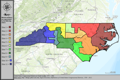 |
%2C_1973_%E2%80%93_1982.tif.png) |
1973–75: 7 Democrats, 4 Republicans
1975–77: 9 Democrats, 2 Republicans 1977–79: 9 Democrats, 2 Republicans 1979–81: 9 Democrats, 2 Republicans 1981–83: 7 Democrats, 4 Republicans |
| 1983–1992 | 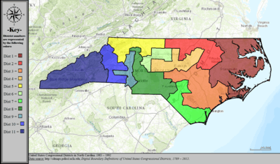 |
%2C_1983_%E2%80%93_1992.tif.png) |
1983–85: 9 Democrats, 2 Republicans
1985–87: 6 Democrats, 5 Republicans 1987–89: 8 Democrats, 3 Republicans 1989–91: 8 Democrats, 3 Republicans 1991–93: 7 Democrats, 4 Republicans |
| 1993–1998 | 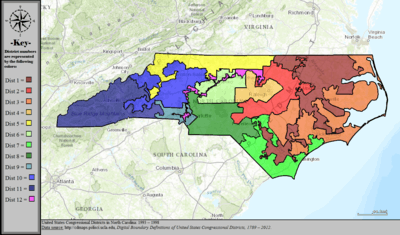 |
%2C_1993_%E2%80%93_1998.tif.png) |
1993–95: 8 Democrats, 4 Republicans
1995–97: 4 Democrats, 8 Republicans 1997–99: 6 Democrats, 6 Republicans |
| 1999–2000 | 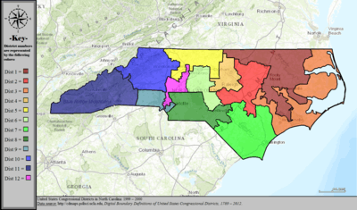 |
%2C_1999_%E2%80%93_2000.tif.png) |
1999–2001: 5 Democrats, 7 Republicans |
| 2001–2002 | 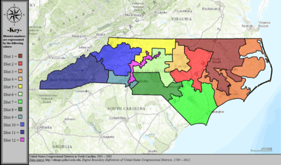 |
%2C_2001_%E2%80%93_2002.tif.png) |
2001–03: 5 Democrats, 7 Republicans |
| 2003–2013 | 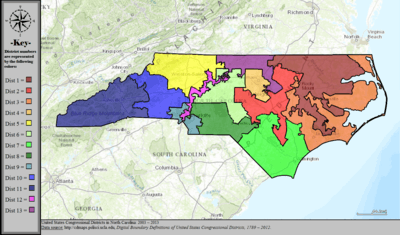 |
%2C_2003_%E2%80%93_2013.tif.png) |
2003–05: 6 Democrats, 7 Republicans
2005–07: 6 Democrats, 7 Republicans 2007–09: 7 Democrats, 6 Republicans 2009–11: 8 Democrats, 5 Republicans 2011–13: 7 Democrats, 6 Republicans |
| 2013–2016 | 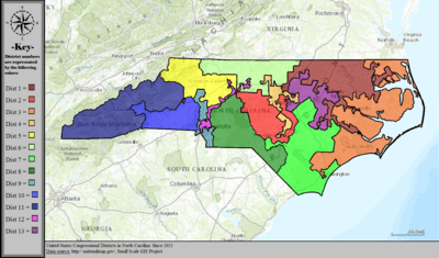 |
%2C_since_2013.tif.png) |
2013–15: 4 Democrats, 9 Republicans
2015–16: 3 Democrats, 10 Republicans |
See also
References
- ↑ http://www.ncleg.net/representation/Content/Plans/PlanPage_DB_2016.asp?Plan=2016_Contingent_Congressional_Plan_-_Corrected&Body=Congress
- ↑ Blinder, Alan (2018). "North Carolina Congressional Map Ruled Unconstitutionally Gerrymandered". The New York Times. ISSN 0362-4331. Retrieved 2018-01-09.
- ↑ http://www.charlotteobserver.com/news/politics-government/article58760423.html
- ↑ https://www.reuters.com/article/us-usa-court-voters-idUSKBN18I1SG?il=0
- ↑ http://www.slate.com/articles/news_and_politics/jurisprudence/2017/05/in_cooper_v_harris_the_supreme_court_strikes_a_blow_against_racial_redistricting.html
- ↑ Blinder, Alan (2018). "North Carolina Congressional Map Ruled Unconstitutionally Gerrymandered". The New York Times. ISSN 0362-4331. Retrieved 2018-01-09.
- ↑ "Supreme Court Blocks Redrawing of North Carolina Congressional Maps". Reuters. Retrieved 2018-01-20.
- ↑ "Digital Boundary Definitions of United States Congressional Districts, 1789–2012". Retrieved October 18, 2014.