North Bondi, New South Wales
| North Bondi Sydney, New South Wales | |||||||||||||||
|---|---|---|---|---|---|---|---|---|---|---|---|---|---|---|---|
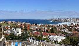 General view of North Bondi | |||||||||||||||
|
North Bondi | |||||||||||||||
| Coordinates | 33°53′16″S 151°16′51″E / 33.88778°S 151.28083°ECoordinates: 33°53′16″S 151°16′51″E / 33.88778°S 151.28083°E | ||||||||||||||
| Population | 9,165 (2016 census)[1] | ||||||||||||||
| • Density | 7,274/km2 (18,840/sq mi) | ||||||||||||||
| Established | 1851 | ||||||||||||||
| Postcode(s) | 2026 | ||||||||||||||
| Area | 1.26 km2 (0.5 sq mi) | ||||||||||||||
| Location | 7 km (4 mi) east of Sydney CBD | ||||||||||||||
| LGA(s) | Waverley Council | ||||||||||||||
| State electorate(s) | Vaucluse | ||||||||||||||
| Federal Division(s) | Wentworth | ||||||||||||||
| |||||||||||||||
North Bondi is a coastal, eastern suburb of Sydney, in the state of New South Wales, Australia 7 kilometres east of the Sydney central business district, in the local government area of Waverley Council.
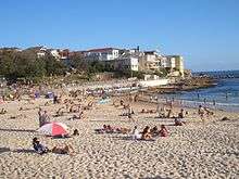
North Bondi is a mostly residential area bordering Bondi Beach and the suburb of Bondi, as well as Bondi Junction, the commercial centre. Ben Buckler is a locality in North Bondi.
History
Bondi is an Aboriginal word meaning water breaking over rock. It has been spelled a number of different ways over time, Boondi, Bundi, Bundye. Rock carvings can be found on the cliffs at North Bondi. The whole Bondi area was part of a 81-hectare (200-acre) land grant to road-builder William Roberts in 1809. In 1851, Edward Smith Hall, editor of the Sydney Monitor, purchased the land for A₤200.[3]
Heritage listings
North Bondi has a number of heritage-listed sites, including:
Rathouse
On 22 March 1944, original members of the Rats of Tobruk formed the North Bondi Sub-Branch of the Returned and Services League of Australia and it is still known in modern times as Tobruk House or The Rathouse.[5] In 2003, the New York Times ran an article on The Rathouse calling it "an ideal beachside hang out."[6]
Ben Buckler Gun Battery
The Battery was constructed in 1892 and was intended to protect the colony and the approaches to Sydney Harbour from enemy vessels standing off the coast. During the 1950s the army vacated the premises and the fortification was buried. In the mid-1990s, the site was excavated by Water Board engineers planning to install a new pipeline. The site has been reburied and is currently under Hugh Bamford Reserve.[7][8]
Tram to North Bondi
Tram services to North Bondi from the CBD operated from either Circular Quay (via Bridge and Elizabeth Streets) or Railway Square (via Elizabeth and Liverpool Streets), to Oxford Street. The line then passed down Oxford Street to Bondi Junction, where it branched off from Bronte services, to run down Bondi Road to Fletcher Street, Campbell Parade and then to the North Bondi tram terminus. A feature of this line was the large 3 track terminus cut into a hillside at North Bondi, which opened in 1946, as well as an underpass at 331a Bondi Road. Trams entered onto Campbell Parade via the under pass at a point where Bondi Road was too steep. The underpass and cutting have now been filled in, part of which is now public reserve and units.[9][10]
The line opened in 1884 as a steam tramway to Bondi, then to Bondi Beach in 1894. Electric services commenced in 1902. The line closed in 1960. The tram line followed the current route of bus 380 as far as North Bondi.
The service also travelled via Paddington and Bellevue Hill. Heading south down Elizabeth Street from Circular Quay, the line turned left into Park Street, then wound through East Sydney. A feature was the tram only viaduct over Barcom Avenue and Boundary Street in Darlinghurst as the line headed into MacDonald Street. This viaduct is now a road bridge. The line then travelled to Paddington and down Curlewis Street in Bondi to join the Bondi Beach via the Bondi Junction line on Campbell Parade, to the North Bondi terminus. The line follows approximately the current route of bus 389.[2]
Landmarks
- Bondi Golf & Diggers Club sits on the coast, east of Military Road.
- North Bondi Surf Life Saving Club sits beside the beach in Biddigal Reserve.
- Aboriginal rock carvings are located on a rocky surface between the sewerage ventilation shaft near Bondi Golf Course and the cliff. A nearby group of carvings were done by Europeans and are thought to have been the work of Portuguese sailors in the nineteenth century. Another Aboriginal carving can be found at Ben Buckler, the headland immediately east of Bondi Beach. It is approximately a metre long and represents a turtle.
Sport and recreation
Since 1908, North Bondi has been represented in one of Australia's most popular sporting competitions, the National Rugby League, by the Sydney Roosters, officially known as the Eastern Suburbs District Rugby League Football Club.
Gallery
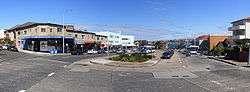
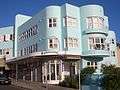 Art Deco shops and flats
rock_carvings_bondi-3.JPG) Aboriginal rock carvings near golf course
Aboriginal rock carvings near golf courserock_carvings_Bondi-5.JPG) Aboriginal rock carvings
Aboriginal rock carvings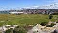 Bondi Golf Course
References
- ↑ Australian Bureau of Statistics (31 October 2012). "North Bondi (State Suburb)". 2011 Census QuickStats. Retrieved 2 May 2015.

- 1 2 http://www.bondivillage.com/tramrems.htm
- ↑ Pollon, Frances, ed. (1990). The Book of Sydney Suburbs. Angus & Robertson. p. 33. ISBN 0-207-14495-8.
- ↑ "Ben Buckler Gun Battery 1893, 9.2 Disappearing Gun, New South Wales State Heritage Register (NSW SHR) Number H01742". New South Wales State Heritage Register. Office of Environment and Heritage. Retrieved 18 May 2018.
- ↑ "The Rathouse History". Tobrukhouse.com. Retrieved 6 September 2009.
- ↑ Borden, Margaret (16 November 2003). "Bondi, Beyond The Beach" (Section 5). New York Times. p. 10.
- ↑ Welcome to Waverley Library Archived 1 September 2007 at the Wayback Machine.
- ↑ NSW Heritage Office Website - Listing Heritage Items - State Heritage Register - Item View
- ↑ http://www.bondivillage.com/tramsyd.htm
- ↑ http://www.secretsofasydneypast.com/2008/02/tram-to-bondi.html
External links
| Wikimedia Commons has media related to North Bondi, New South Wales. |