North Avondale, Colorado
| North Avondale, Colorado | |
|---|---|
| Unincorporated community | |
 Location in Pueblo County and the state of Colorado  North Avondale, Colorado (the US) | |
| Coordinates: 38°15′42″N 104°20′56″W / 38.26167°N 104.34889°WCoordinates: 38°15′42″N 104°20′56″W / 38.26167°N 104.34889°W | |
| Country |
|
| State |
|
| County | Pueblo[1] |
| Elevation[1] | 4,518 ft (1,377 m) |
| Time zone | UTC-7 (MST) |
| • Summer (DST) | UTC-6 (MDT) |
| ZIP code[2] | 81022 (Avondale) |
| Area code(s) | 719 |
| GNIS feature ID | 0193754 |
North Avondale is an unincorporated community in Pueblo County, Colorado, United States. The U.S. Post Office at Avondale (ZIP Code 81022) now serves North Avondale postal addresses.[2]
Geography
North Avondale is located at 38°15′42″N 104°20′56″W / 38.26167°N 104.34889°W (38.261637,-104.349003).
References
- 1 2 "US Board on Geographic Names". United States Geological Survey. 2007-10-25. Retrieved 2008-01-31.
- 1 2 "ZIP Code Lookup". United States Postal Service. January 3, 2007. Archived from the original (JavaScript/HTML) on January 1, 2008. Retrieved January 3, 2007.
Municipalities and communities of Pueblo County, Colorado, United States | ||
|---|---|---|
| City | 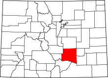 | |
| Towns | ||
| CDPs | ||
| Unincorporated communities | ||
| Ghost town | ||
This article is issued from
Wikipedia.
The text is licensed under Creative Commons - Attribution - Sharealike.
Additional terms may apply for the media files.