Nonoava Municipality
| Nonoava | |
|---|---|
| Municipality | |
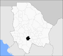 Municipality of Nonoava in Chihuahua | |
|
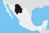
Nonoava Location in Mexico | |
| Coordinates: 27°28′15″N 106°44′04″W / 27.47083°N 106.73444°WCoordinates: 27°28′15″N 106°44′04″W / 27.47083°N 106.73444°W | |
| Country |
|
| State | Chihuahua |
| Municipal seat | Nonoava |
| Area | |
| • Total | 2,693.3 km2 (1,039.9 sq mi) |
| Population (2010) | |
| • Total | 2,849 |
| • Density | 1.1/km2 (2.7/sq mi) |
Nonoava is one of the 67 municipalities of Chihuahua, in north-western Mexico. The municipal seat lies at Nonoava. The municipality covers an area of 2,693.3 km².
As of 2010, the municipality had a total population of 2,849,[1] up from 2,810 as of 2005.[2]
As of 2010, the town of Nonoava had a population of 1,272.[1] Other than the town of Nonoava, the municipality had 168 localities, none of which had a population over 1,000.[1]
Geography
Towns and villages
The municipality has 59 localities. The largest are:
| Name | Population (2005) |
|---|---|
| Nonoava | 1,209 |
| El Terrero | 388 |
| Humariza | 289 |
| La Junta de los Ríos | 190 |
| Total Municipality | 2,810 |
References
- 1 2 3 "Nonoava". Catálogo de Localidades. Secretaría de Desarrollo Social (SEDESOL). Retrieved 23 April 2014.
- ↑ "Nonoava". Enciclopedia de los Municipios de México. Instituto Nacional para el Federalismo y el Desarrollo Municipal. Retrieved October 19, 2008.
This article is issued from
Wikipedia.
The text is licensed under Creative Commons - Attribution - Sharealike.
Additional terms may apply for the media files.