Nogat
| Nogat River | |
|---|---|
 | |
| Country | Poland |
| Physical characteristics | |
| Main source |
Anabranch of the Vistula River near Biała Góra 53°54′43″N 18°52′47″E / 53.91194°N 18.87972°E |
| River mouth |
Vistula Lagoon 54°16′38″N 19°15′38″E / 54.27722°N 19.26056°ECoordinates: 54°16′38″N 19°15′38″E / 54.27722°N 19.26056°E |
| Length | 62 km (39 mi) |
| Basin features | |
| Basin size | 1,130 km2 (440 sq mi) |
The Nogat is a 62 km long delta branch of the Vistula River and does not empty at Gdańsk Bay as the main river does.
The Nogat has its origin near the city of Biała Góra as an anabranch of the Vistula River. Shortly after the river Liwa flows into the Nogat. Then the river passes Malbork and winds NE towards Elbląg (but does not reach the city). NW of Elbląg the Nogat flows into the SW part of the Vistula Lagoon.
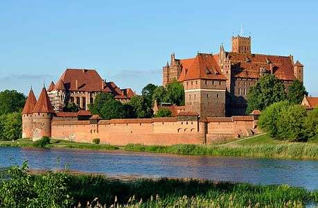
Malbork Castle on the Nogat
During the interwar period, the Nogat formed the German boundary with the Free State of Danzig.
Tributaries of the Vistula River | ||
|---|---|---|
| Forming rivers |
|  |
| Main tributaries of the left bank | ||
| Main tributaries of the right bank |
| |
| Distributary | ||
This article is issued from
Wikipedia.
The text is licensed under Creative Commons - Attribution - Sharealike.
Additional terms may apply for the media files.