Noailhac, Aveyron
| Noailhac | |
|---|---|
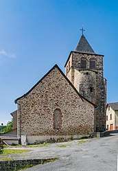 Saint Jean Baptiste Church | |
 Noailhac Location within Occitanie region  Noailhac | |
| Coordinates: 44°34′01″N 2°22′34″E / 44.5669°N 2.3761°ECoordinates: 44°34′01″N 2°22′34″E / 44.5669°N 2.3761°E | |
| Country | France |
| Region | Occitanie |
| Department | Aveyron |
| Arrondissement | Rodez |
| Canton | Lot et Dourdou |
| Government | |
| • Mayor (2008–2014) | Abel Bonnefous |
| Area1 | 15.96 km2 (6.16 sq mi) |
| Population (2008)2 | 177 |
| • Density | 11/km2 (29/sq mi) |
| Time zone | UTC+1 (CET) |
| • Summer (DST) | UTC+2 (CEST) |
| INSEE/Postal code | 12173 /12320 |
| Elevation |
280–625 m (919–2,051 ft) (avg. 588 m or 1,929 ft) |
|
1 French Land Register data, which excludes lakes, ponds, glaciers > 1 km2 (0.386 sq mi or 247 acres) and river estuaries. 2 Population without double counting: residents of multiple communes (e.g., students and military personnel) only counted once. | |
Noailhac is a former commune in the Aveyron department in southern France. On 1 January 2016, it was merged into the new commune of Conques-en-Rouergue.[1]
Population
| Historical population | ||
|---|---|---|
| Year | Pop. | ±% |
| 1962 | 255 | — |
| 1968 | 286 | +12.2% |
| 1975 | 234 | −18.2% |
| 1982 | 231 | −1.3% |
| 1990 | 195 | −15.6% |
| 1999 | 193 | −1.0% |
| 2008 | 177 | −8.3% |
See also
References
- ↑ Arrêté préfectoral 19 November 2015
| Wikimedia Commons has media related to Noailhac (Aveyron). |
This article is issued from
Wikipedia.
The text is licensed under Creative Commons - Attribution - Sharealike.
Additional terms may apply for the media files.