Nishinoshima (Ogasawara)
| Native name: 西之島 | |
|---|---|
|
Nishinoshima in July 2016 | |
 Nishinoshima Nishinoshima (Japan) | |
| Geography | |
| Location | Pacific Ocean |
| Coordinates | 27°14′49″N 140°52′28″E / 27.24694°N 140.87444°ECoordinates: 27°14′49″N 140°52′28″E / 27.24694°N 140.87444°E |
| Total islands | 1 |
| Area | 3 km2 (1.2 sq mi) |
| Highest elevation | 143 m (469 ft) |
| Administration | |
|
Japan | |
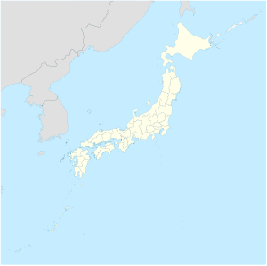
| Prefecture | Tokyo |
| Subprefecture | Ogasawara Subprefecture |
| Village | Ogasawara |
| Demographics | |
| Population | 0 |
Nishi-no-shima (Japanese: 西之島, "western island") is a volcanic island located around 940 km (584 mi) south-southeast of Tokyo,[1] that is part of the Volcano Islands arc. It has also been known as Rosario Island.[2]
Originally the above-water part of the ridge of an underwater caldera, Nishinoshima was enlarged in 1974 after fresh eruptions created a new section of the island. Another eruption that began in November 2013 further enlarged the island and attracted worldwide attention.[3][4][5] A volcanic cone soon formed, raising to an estimated height of 142 m (466 ft) by July 2016.[1][6] The eruptions ceased by November 2015, though emissions of volcanic gases continued for several months afterwards. In April 2017, new eruptions on the island were reported.[7]
As of 2016, the island is about 2.7 km² (667.18 acres) in size and evinces the return of various plants and animal species.[8]
Etymology
The island was named "Rosario Island" when it was discovered by the Spanish ship Rosario in 1702. That was the island's name until 1904 when the Japanese term "Nishinoshima" (literally, "West Island") was made the official name.[9]
When a new island was formed in the 1973 eruption, that was called Nishinoshima Shintō (西之島新島, literally, "New Nishinoshima Island"), but due to erosion and shifting sands, that island joined the main island and ceased to be a separate entity.[9]
During the early stages of the 2013 eruption, a new volcanic island was formed about southeast from the original Nishinoshima. The island was not given an official name but was mentioned in Japanese reports as "new island": atarashii shima (新しい島) or shintō (新島).[10] Government officials said the island would be named "after it is stable and it is clear it will remain".[11] As the island has now merged with Nishinoshima, "there is little possibility it will be named as a separate entity."[12]
Geology
Morphology
Prior to 1974, Nishinoshima was a small, green island which had no eruptions in the past 10,000 years. The island was merely the tip of an undersea volcano some 3,000 m (9,800 ft) in height and 30 km (19 mi) wide at the base.[13] Its main period of activity was from the Late Pleistocene to the Holocene.[14] The volcano takes the form of a caldera, with the original Nishinoshima and some nearby rocks forming part of the northwest ridge of a caldera about 1 km (0.6 mi) in diameter.[15] The island was originally about 650 m (710 yd) long and 200 m (220 yd) wide.[9] A 1911 survey determined the caldera was 107 m (351 ft) at its deepest.[13] The volcano has many large, submarine, satellite cones to the south, west and northeast. The southern cone rises to within 196 m (643 ft) of the surface, around 9 km (6 mi) SSE of Nishinoshima.[13]
1973–1974 Eruption
On 30 May 1973, the crew of a passing ship noted that, at around 11:00, white smoke rose east of the island to around 100 m (330 ft) in the air every few minutes. An aerial inspection the next day said that the eruption was taking place 400 m (440 yd) east of the island. A whirlpool was also seen. Yellow-green sea water and floating pumice were seen 5 km (3 mi) north of the site. Another crew discovered that two black rocks were rising from the sea.
In July, the eruption continued to erupt water fountains every few minutes with white smoke rising to 100 m above sea level. An aerial inspection on 14 September noted that a new island had formed above the submarine eruption site, the island formed a cinder cone around 40 m (130 ft) high and 120 m (130 yd) across. The new island had a 70 m (77 yd) diameter crater that frequently ejected cinders to a maximum height of 300 m (980 ft). White smoke rose to a height around 1,500 m (4,900 ft) high.
In November, a fissure eruption was noted on the new island with a chain of cinder cones running from southwest to northeast, the most recent cones were formed at the end of the chain, with the original cone being destroyed by the waves. The cones were erupting ash to a height of around 300 m (980 ft).
In December, the new island grew larger than "old" Nishinoshima. The island was 700 m (770 yd) long and 250 m (270 yd) wide; the new island had now developed a central crater that rose to a maximum height of 40 m (130 ft). The cone was continuing to eject ash and cinders to a height of 100 m (330 ft). A small craterlet on the new island was also emitting lava flows.
By February 1974, the new island had developed two cinder cones at the western end of the new island, but only the eastern cinder cone was erupting. Observations on 11 January noted that the active eastern cinder cone was emitting a lava flow.
In March, the new island was still erupting; by then, the island had five cinder cones; one cinder cone was erupting red hot lava. Lava flows were still erupting from the new island's flanks. On March 1, the five cinder cones were quiet, but a large lava flow may have still been effusing from the island's flanks. After that, the eruption ended; wave movements then joined the new and old islands.
2013–2015 eruption
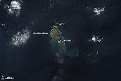
In November 2013, an eruption created a new, small island south-southeast off the shore of the original island.[4][5][16][17] By December 2013, the island rose 20–25 m (66–82 ft) above sea level, with an area of 56,000 square meters (13.8 acres). The island was considered large enough to maintain a presence above sea level for at least several years.[18][19] By 20 December 2013, the island had grown fast enough that experts predicted that it would probably join up with Nishinoshima before the end of 2013, and cease to be a separate island.[20] On 26 December 2013, the Japanese Coast Guard confirmed that the two islands had joined.[21]
The United States space agency, NASA, says two cones have formed around the main volcanic vents and stand more than 60 m (200 ft) above sea level.[3] The newer portion of the island is now larger than the original Nishinoshima landmass. The merged island is slightly more than 1 km (0.6 mi) across.
During July and August 2014, lava flow increased, causing the island to expand rapidly to the east. Between September and December, the lava flow increased further and headed north, almost completely overrunning the pre-existing island.[22] On 27 December 2014, Japanese authorities said the island had reached nearly 2.3 km2 (570 acres) in size and is estimated to have risen to about 110 m (360 ft) above the sea level and that the volcano was still active.[6] A pyroclastic cone formed around the vents which further rose the island to about 135 m (442 ft) by 23 February 2015.[1][23]
The eruption continued throughout the first half of 2015, and the island continued to expand. However, by August, the volcano ceased to erupt smoke and ash, but continued to emit lava.[24] As of September 16, 2015, the total area of the island had decreased slightly, but the fumarolic zone had expanded as "vigorous volcanic activity continued without significant change".[25] Eruptions resumed soon thereafter,[26] but November 17, 2015, was the date of the last observed explosive eruption.[27] Fumarolic activity continued, but decreased in amount as no new lava flows were observed.[27] Decreases in temperatures were also recorded, and subsidence was observed near the summit of the volcano.[27] In August 2016, the Japan Meteorological Agency announced that the alert level for the volcano had been lowered, and that the no-entry zone had been reduced from a radius of 2 km (1.2 mi) to a radius of 500 m (1,600 ft).[27][28] This would finally enable landings on the island. Water discoloration was still evident immediately offshore in August, indicating that volcanic activity, while in significant decline, was still present.[29] On 14 February 2017, the Japan Meteorological Agency cancelled all alerts for the island, declaring that there was no indication of subsequent eruptions.[30]
On October 2016, a team of scientists visited Nishinoshima to conduct research on the island.[8][31] Apart from documenting the island's ecology and geology, monitoring equipment was also installed for future volcanic activity.[32]
The eruption has provided an explanation for the northern Pacific Blob which has puzzled scientists [33]. It is an example of geothermal heat responsible for episodic heating in oceans [34]
2017 eruption
On 20 April 2017, the Japan Coast Guard confirmed explosive eruptions at the No. 7 crater at Nishinoshima and lava flows emerging from the base of volcano. Satellite imagery from 19 April also confirmed high temperatures on the island.[35] Examination of the data revealed that the eruption likely began on 17 April.[36] By 27 April, two lava flows had reached the sea, one on the west shore, the other on the south-west shore of the island.[37] By 29 June, the flows had created two lobes, one extending 330 meters beyond the western shore, and other 310 to the south-west. The area of the island increased to 2.9 km2.[38] By July, surface temperatures began to decrease until they became indistinguishable from the surroundings in August; lava flows also stopped by the end of August.[36] On 3 October, the Coordinating Committee for Prediction of Volcanic Eruptions of the Japan Meteorological Agency announced that Nishinoshima had likely ceased erupting.[36] In June 2018, the JMA announced that the no-entry zone had been reduced from a radius of 2 km (1.2 mi) to a radius of 500 m (1,600 ft).[39] Within a month, however, the zone was returned to 1500m after small eruptions were spotted on July 12, 2018.[40]
Ecology
Since the 2013 eruption, biologists have expressed great interest in how Nishinoshima would be colonized by plants and wildlife. It is expected that organic matter, mainly deposited by nesting birds in the form of feathers or excrement, would enrich the island surface for plants to grow.[41] To prevent interference of the colonization process, researchers were also advised not to bring external species to Nishinoshima.
On October 2016, a team of scientists visited Nishinoshima to examine its environment and geologic makeup for the first time up-close.[8][31] Their studies have discovered that both plant and animal life continue to exist on the remaining part of the old Nishinoshima island that had not been covered by lava. An accompanying video crew from Nippon TV captured masked boobies laying eggs and a pod of dolphins (either Indo-Pacific or common bottlenose) swimming off the coast.[31] Gannets, bramblings and earwigs were also discovered living on the island by researchers.[42] Several cetaceans have been known to live around the island prior to the eruption such as spinner dolphins and short-finned pilot whales,[43] and above mentioned bottlenose dolphin. Humpback whales had been seen before the eruption,[44] and their recent returns have been confirmed as well.[45]
In terms of flora, plants that were present on the original island like goosegrass and purslane were found to be growing again on the "old" section of Nishinoshima.[42]
See also
References
- 1 2 3 Smithsonian Institution, Global Volcanism Program
- ↑ Freeman, Otis W. (1951). Geography of the Pacific, pp. 229-235.
- 1 2 Volcanic islands merge in Pacific Ocean BBC, 8 April 2014
- 1 2 "Volcanic Blast Forms New Island Near Japan". Universetoday.com. 2013-11-21. Retrieved 2014-04-06.
- 1 2 "Volcano Eruption Creates New Island". International Business Times. 21 November 2013. Retrieved 22 November 2013. with pictures.
- 1 2 http://www1.kaiho.mlit.go.jp/GIJUTSUKOKUSAI/kaiikiDB/kaiyo18-e1.htm
- ↑ "Nishinoshima island south of Tokyo erupts, lava heads to sea". The Asahi Shimbun. Retrieved 23 April 2017.
- 1 2 3 "Japan team swims in for first up-close look at newly formed volcanic isle". The Japan Times Online. 2016-10-28. ISSN 0447-5763. Retrieved 2016-12-15.
- 1 2 3 "Nishinoshima". Kotobank. Asahi Shinbun. Retrieved 18 February 2014.
- ↑ "しんとう". Hokkaidō Shinbun. 12 January 2014. Retrieved 16 January 2014.
- ↑ "名もなき新島、どんな運命 残れば領海わずかに拡大? 小笠原諸島". Asashi Shimbun. 26 November 2013.
- ↑ "Lava flow connects new islet with Nishinoshima island". Asahi Shimbun. 26 December 2013. Retrieved 27 December 2013.
- 1 2 3 Nakano, Shun. "Kaitei chikei". Nishinoshima Kazan (in Japanese). Geological Survey of Japan. Retrieved 17 February 2014.
- ↑ "Nishinoshima". Geological Survey of Japan. Retrieved 17 February 2014.
- ↑ Nakano, Shun. "Gaiyō". Nishinoshima Kazan (in Japanese). Geological Survey of Japan. Retrieved 17 February 2014.
- ↑ "Volcano raises new island far south of Japan". Times of India. 21 November 2013. Retrieved 21 November 2013.
- ↑ Netburn, Deborah. "Is Niijima here to stay? New image of the newest island on Earth". latimes.com. Retrieved 2013-12-20.
- ↑ "New volcanic island off Japan still growing in ongoing eruptions". UPI.com. Retrieved 2013-12-20.
- ↑ "Japan's newly created island is actually growing". Salon.com. Retrieved 2013-12-20.
- ↑ 新島、年内につながる可能性 西之島まで百メートル切る. 47News (in Japanese). Retrieved 20 December 2013.
- ↑ 新島、西之島と一体化=海保が確認. Jiji.com (in Japanese). Jiji Tsūshinsha. Retrieved 26 December 2013.
- ↑ "Nishinoshima coastlines".
- ↑ "Nishinoshima". www1.kaiho.mlit.go.jp. Retrieved 2016-12-16.
- ↑ "Volcanic activity".
- ↑ "⻄之島の火山活動の状況(9月16日観測)" (PDF) (in Japanese). Japan Coast Guard. Retrieved 18 September 2015.
- ↑ "全国月間火山概況(平成27年10月)" (PDF) (in Japanese). Japan Meteorological Agency. Retrieved 16 December 2016.
- 1 2 3 4 "西之島の火山活動解説資料" (PDF) (in Japanese). Japan Meteorological Agency. Retrieved 16 December 2016.
- ↑ "西之島 警報レベル引き下げ 警戒範囲は500mに縮小 3年ぶり". www.hazardlab.jp. Retrieved 16 December 2016.
- ↑ "西之島 の火山活動の状況(8月18日観測)" (PDF) (in Japanese). Japan Coast Guard. Retrieved 16 December 2016.
- ↑ "西之島の警報解除=上陸ルール、徹底呼び掛け:時事ドットコム". Jiji News (in Japanese). Retrieved 21 April 2017.
- 1 2 3 earthsky102 (2016-11-14), First Visit to Nishinoshima Volcano Island, South Japan #西之島, retrieved 2016-12-15
- ↑ "Island volcano monitoring system tested at Nishinoshima". Retrieved 2016-12-16.
- ↑ Wyss Yim - Explanation for the north Pacific Blob. Imperial Engineer Autumn 2016, p. 15
- ↑ Wyss Yim - Geothermal heat: an episodic heat source in oceans. Imperial Engineer Spring 2017, p. 14-15.
- ↑ "西之島 活動再開の可能性?気象庁の警報解除からわずか2ヵ月 | ハザードラボ". Hazard Lab (in Japanese). Retrieved 21 April 2017.
- 1 2 3 "西之島は再び「お休みモード」へ 地表の熱が低下 噴火予知連 | ハザードラボ". Hazard Lab (in Japanese). Earth Scientific. Retrieved 4 October 2017.
- ↑ "西之島 溶岩流が海に到達!「マグマ上昇で激しい噴火のおそれ」海保 | ハザードラボ". Hazard Lab (in Japanese). Retrieved 30 April 2017.
- ↑ "西之島 活動再開で東西に伸びる「30秒間隔で噴火」海保". Hazard Lab (in Japanese). Retrieved 12 July 2017.
- ↑ "西之島の警戒が必要な範囲を1.5kmから500mに縮小しました". 報道発表資料 (in Japanese). Japan Meteorological Agency. Retrieved 20 June 2018.
- ↑ "西之島の火山活動解説資料" (PDF). Japanese Meteorological Agency. Retrieved 22 July 2018.
- ↑ "Nishinoshima: How bird poop will bring life to a mysterious new island". Washington Post. Retrieved 2016-12-16.
- 1 2 "First survey finds life goes on after eruptions on Nishinoshima:The Asahi Shimbun". The Asahi Shimbun. Retrieved 2016-12-16.
- ↑ Hidaka T.. Kasuya T.. Izawa K.. Kawamichi T.. 1996. The encyclopaedia of animals in Japan (2) - Mammals 2. ISBN 9784582545524 (9784582545517) (4582545521). Heibonsha
- ↑ Ogasawara Whale Watching Association. 2017. The last 硫黄三島&西之島 cruise of the second Ogasawaramaru. "Megaptera" the organa bulletin. Vol.73 and74. ISSN: 1343 - 3091. Retrieved on March 25, 2017
- ↑ Nishinoshima New Island and whales. YouTube. Retrieved on April 04, 2017
External links
- Nishinoshima, Ogasawara by Geospatial Information Authority of Japan (in Japanese)
- Nishinoshima eruption observed by LANDSAT 8, Geospatial Information Authority of Japan
- Global Volcanism Program
- Nishinoshima, Kaiiki Kazan Database, Japan Coast Guard (in Japanese)
- New Japanese Island Forming in Pacific Ocean: Photos, 22 November 2013
- New island at NASA's Earth Observatory website